You are here: Home > Network List > PO - Portable Observatories for Lithospheric Analysis and Research Investigating Seis Stations List
> Station CHGQ Chibougamau, QC > Earthquake Result Viewer
CHGQ Chibougamau, QC - Earthquake Result Viewer
| Earthquake location: |
Guerrero, Mexico |
| Earthquake latitude/longitude: |
17.3/-100.8 |
| Earthquake time(UTC): |
2014/05/10 (130) 07:36:03 GMT |
| Earthquake Depth: |
35 km |
| Earthquake Magnitude: |
6.0 MB |
| Earthquake Catalog/Contributor: |
NEIC PDE/NEIC COMCAT |
|
| Network: |
PO Portable Observatories for Lithospheric Analysis and Research Investigating Seis |
| Station: |
CHGQ Chibougamau, QC |
| Lat/Lon: |
49.91 N/74.37 W |
| Elevation: |
406 m |
|
| Distance: |
38.9 deg |
| Az: |
27.233 deg |
| Baz: |
222.558 deg |
| Ray Param: |
0.07523623 |
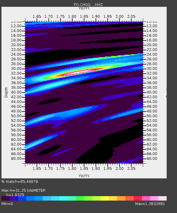
| Estimated Moho Depth: |
31.25 km |
| Estimated Crust Vp/Vs: |
1.83 |
| Assumed Crust Vp: |
6.61 km/s |
| Estimated Crust Vs: |
3.607 km/s |
| Estimated Crust Poisson's Ratio: |
0.29 |
|
| Radial Match: |
95.44876 % |
| Radial Bump: |
265 |
| Transverse Match: |
82.306465 % |
| Transverse Bump: |
400 |
| SOD ConfigId: |
626651 |
| Insert Time: |
2014-05-24 08:35:19.269 +0000 |
| GWidth: |
2.5 |
| Max Bumps: |
400 |
| Tol: |
0.001 |
|

Signal To Noise
| Channel | StoN | STA | LTA |
| PO:CHGQ: :HHZ:20140510T07:42:55.529994Z | 26.98505 | 7.9284E-7 | 2.9380711E-8 |
| PO:CHGQ: :HHN:20140510T07:42:55.529994Z | 11.534863 | 2.7500263E-7 | 2.3840997E-8 |
| PO:CHGQ: :HHE:20140510T07:42:55.529994Z | 16.156223 | 3.852794E-7 | 2.384712E-8 |
| Arrivals |
| Ps | 4.2 SECOND |
| PpPs | 12 SECOND |
| PsPs/PpSs | 17 SECOND |


