You are here: Home > Network List > PR - Puerto Rico Seismic Network (PRSN) & Puerto Rico Strong Motion Program (PRSMP) Stations List
> Station CUPR Culebra > Earthquake Result Viewer
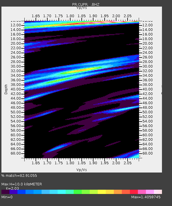
CUPR Culebra - Earthquake Result Viewer
| Earthquake location: |
Guerrero, Mexico |
| Earthquake latitude/longitude: |
17.3/-100.8 |
| Earthquake time(UTC): |
2014/05/10 (130) 07:36:03 GMT |
| Earthquake Depth: |
35 km |
| Earthquake Magnitude: |
6.0 MB |
| Earthquake Catalog/Contributor: |
NEIC PDE/NEIC COMCAT |
|
| Network: |
PR Puerto Rico Seismic Network (PRSN) & Puerto Rico Strong Motion Program (PRSMP) |
| Station: |
CUPR Culebra |
| Lat/Lon: |
18.31 N/65.28 W |
| Elevation: |
7.0 m |
|
| Distance: |
33.8 deg |
| Az: |
82.75 deg |
| Baz: |
273.843 deg |
| Ray Param: |
0.07800081 |
| Estimated Moho Depth: |
10.0 km |
| Estimated Crust Vp/Vs: |
2.03 |
| Assumed Crust Vp: |
5.14 km/s |
| Estimated Crust Vs: |
2.532 km/s |
| Estimated Crust Poisson's Ratio: |
0.34 |
|
| Radial Match: |
82.91055 % |
| Radial Bump: |
400 |
| Transverse Match: |
71.88393 % |
| Transverse Bump: |
400 |
| SOD ConfigId: |
626651 |
| Insert Time: |
2014-05-24 08:36:45.023 +0000 |
| GWidth: |
2.5 |
| Max Bumps: |
400 |
| Tol: |
0.001 |
|

Signal To Noise
| Channel | StoN | STA | LTA |
| PR:CUPR: :BHZ:20140510T07:42:11.925013Z | 7.7128816 | 2.3943774E-6 | 3.1043874E-7 |
| PR:CUPR: :BHN:20140510T07:42:11.925013Z | 2.6878874 | 6.40472E-7 | 2.3828082E-7 |
| PR:CUPR: :BHE:20140510T07:42:11.925013Z | 4.169224 | 1.4184075E-6 | 3.40209E-7 |
| Arrivals |
| Ps | 2.1 SECOND |
| PpPs | 5.7 SECOND |
| PsPs/PpSs | 7.7 SECOND |


