You are here: Home > Network List > II - Global Seismograph Network (GSN - IRIS/IDA) Stations List
> Station KURK Kurchatov, Kazakhstan > Earthquake Result Viewer
KURK Kurchatov, Kazakhstan - Earthquake Result Viewer

| Earthquake location: |
Near East Coast Of Kamchatka |
| Earthquake latitude/longitude: |
52.0/157.3 |
| Earthquake time(UTC): |
2002/10/16 (289) 10:12:21 GMT |
| Earthquake Depth: |
102 km |
| Earthquake Magnitude: |
6.1 MB, 6.2 MW, 6.2 MW |
| Earthquake Catalog/Contributor: |
WHDF/NEIC |
|
| Network: |
II Global Seismograph Network (GSN - IRIS/IDA) |
| Station: |
KURK Kurchatov, Kazakhstan |
| Lat/Lon: |
50.72 N/78.62 E |
| Elevation: |
184 m |
|
| Distance: |
46.9 deg |
| Az: |
301.359 deg |
| Baz: |
56.234 deg |
| Ray Param: |
0.06999915 |
| Estimated Moho Depth: |
42.25 km |
| Estimated Crust Vp/Vs: |
1.71 |
| Assumed Crust Vp: |
6.552 km/s |
| Estimated Crust Vs: |
3.843 km/s |
| Estimated Crust Poisson's Ratio: |
0.24 |
|
| Radial Match: |
97.9862 % |
| Radial Bump: |
292 |
| Transverse Match: |
84.07989 % |
| Transverse Bump: |
400 |
| SOD ConfigId: |
4714 |
| Insert Time: |
2010-03-01 21:58:39.260 +0000 |
| GWidth: |
2.5 |
| Max Bumps: |
400 |
| Tol: |
0.001 |
|
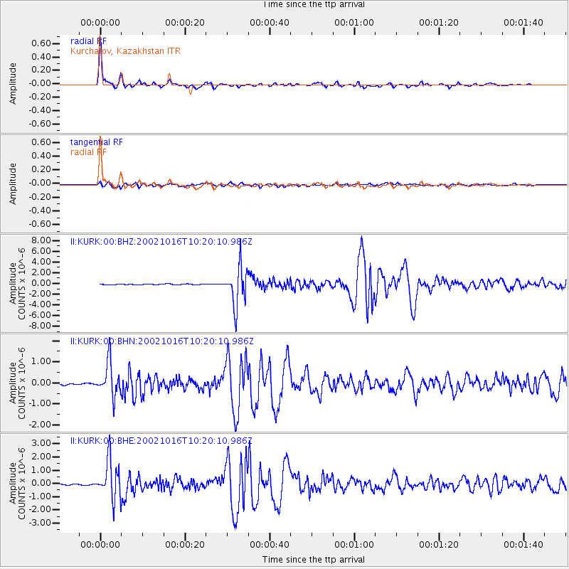
Signal To Noise
| Channel | StoN | STA | LTA |
| II:KURK:00:BHN:20021016T10:20:10.986Z | 19.426647 | 8.26413E-7 | 4.254018E-8 |
| II:KURK:00:BHE:20021016T10:20:10.986Z | 41.33107 | 1.488889E-6 | 3.602348E-8 |
| II:KURK:00:BHZ:20021016T10:20:10.986Z | 52.24108 | 3.535206E-6 | 6.7670996E-8 |
| Arrivals |
| Ps | 4.9 SECOND |
| PpPs | 16 SECOND |
| PsPs/PpSs | 21 SECOND |


