You are here: Home > Network List > TA - USArray Transportable Network (new EarthScope stations) Stations List
> Station D50A G1974 Best Township, ON, CAN > Earthquake Result Viewer
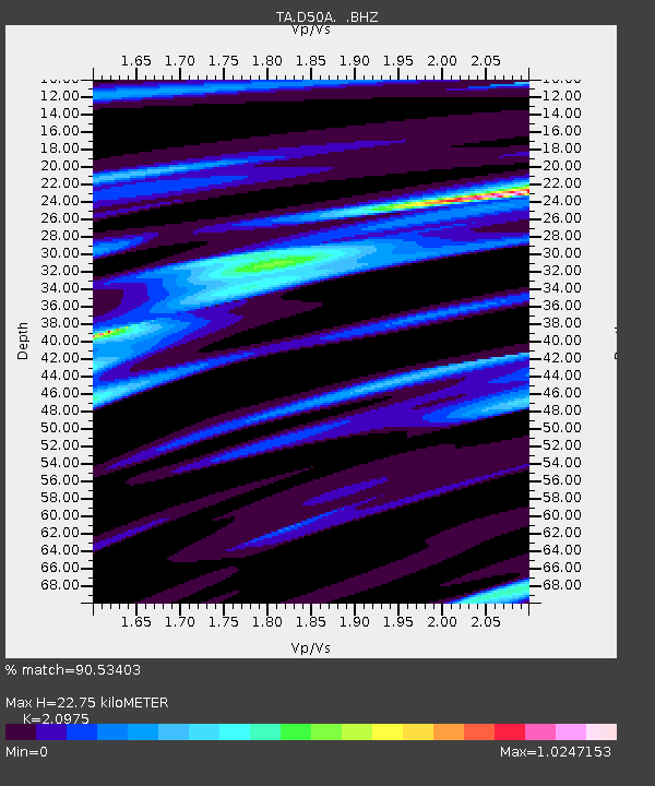
D50A G1974 Best Township, ON, CAN - Earthquake Result Viewer
| Earthquake location: |
Guerrero, Mexico |
| Earthquake latitude/longitude: |
17.3/-100.8 |
| Earthquake time(UTC): |
2014/05/10 (130) 07:36:03 GMT |
| Earthquake Depth: |
35 km |
| Earthquake Magnitude: |
6.0 MB |
| Earthquake Catalog/Contributor: |
NEIC PDE/NEIC COMCAT |
|
| Network: |
TA USArray Transportable Network (new EarthScope stations) |
| Station: |
D50A G1974 Best Township, ON, CAN |
| Lat/Lon: |
47.17 N/79.84 W |
| Elevation: |
331 m |
|
| Distance: |
34.4 deg |
| Az: |
25.503 deg |
| Baz: |
217.082 deg |
| Ray Param: |
0.077671774 |
| Estimated Moho Depth: |
22.75 km |
| Estimated Crust Vp/Vs: |
2.10 |
| Assumed Crust Vp: |
6.622 km/s |
| Estimated Crust Vs: |
3.157 km/s |
| Estimated Crust Poisson's Ratio: |
0.35 |
|
| Radial Match: |
90.53403 % |
| Radial Bump: |
292 |
| Transverse Match: |
62.41572 % |
| Transverse Bump: |
400 |
| SOD ConfigId: |
626651 |
| Insert Time: |
2014-05-24 08:38:16.571 +0000 |
| GWidth: |
2.5 |
| Max Bumps: |
400 |
| Tol: |
0.001 |
|

Signal To Noise
| Channel | StoN | STA | LTA |
| TA:D50A: :BHZ:20140510T07:42:17.850001Z | 23.95481 | 1.8127269E-6 | 7.567277E-8 |
| TA:D50A: :BHN:20140510T07:42:17.850001Z | 15.736083 | 9.574857E-7 | 6.084651E-8 |
| TA:D50A: :BHE:20140510T07:42:17.850001Z | 15.071039 | 6.9517534E-7 | 4.612657E-8 |
| Arrivals |
| Ps | 4.0 SECOND |
| PpPs | 9.9 SECOND |
| PsPs/PpSs | 14 SECOND |


