You are here: Home > Network List > CI - Caltech Regional Seismic Network Stations List
> Station MPM Manuel Prospect Mine, California, USA > Earthquake Result Viewer
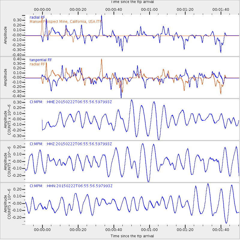
MPM Manuel Prospect Mine, California, USA - Earthquake Result Viewer
*The percent match for this event was below the threshold and hence no stack was calculated.
| Earthquake location: |
Northern Xinjiang, China |
| Earthquake latitude/longitude: |
44.1/85.6 |
| Earthquake time(UTC): |
2015/02/22 (053) 06:42:54 GMT |
| Earthquake Depth: |
12 km |
| Earthquake Magnitude: |
5.0 MW |
| Earthquake Catalog/Contributor: |
ISC/ISC |
|
| Network: |
CI Caltech Regional Seismic Network |
| Station: |
MPM Manuel Prospect Mine, California, USA |
| Lat/Lon: |
36.06 N/117.49 W |
| Elevation: |
185 m |
|
| Distance: |
97.6 deg |
| Az: |
18.668 deg |
| Baz: |
343.454 deg |
| Ray Param: |
$rayparam |
*The percent match for this event was below the threshold and hence was not used in the summary stack. |
|
| Radial Match: |
53.781666 % |
| Radial Bump: |
400 |
| Transverse Match: |
53.92011 % |
| Transverse Bump: |
400 |
| SOD ConfigId: |
7019011 |
| Insert Time: |
2019-04-17 00:21:35.213 +0000 |
| GWidth: |
2.5 |
| Max Bumps: |
400 |
| Tol: |
0.001 |
|
Signal To Noise
| Channel | StoN | STA | LTA |
| CI:MPM: :HHZ:20150222T06:55:56.597993Z | 0.5913808 | 9.714079E-8 | 1.64261E-7 |
| CI:MPM: :HHN:20150222T06:55:56.597993Z | 0.75934005 | 7.9803584E-8 | 1.0509598E-7 |
| CI:MPM: :HHE:20150222T06:55:56.597993Z | 0.85865015 | 8.3375326E-8 | 9.710047E-8 |
| Arrivals |
| Ps | |
| PpPs | |
| PsPs/PpSs | |


