You are here: Home > Network List > TA - USArray Transportable Network (new EarthScope stations) Stations List
> Station D57A Chemin Vers le Barrage, Saint-Michel-Des-Saints, Q > Earthquake Result Viewer
D57A Chemin Vers le Barrage, Saint-Michel-Des-Saints, Q - Earthquake Result Viewer
| Earthquake location: |
Guerrero, Mexico |
| Earthquake latitude/longitude: |
17.3/-100.8 |
| Earthquake time(UTC): |
2014/05/10 (130) 07:36:03 GMT |
| Earthquake Depth: |
35 km |
| Earthquake Magnitude: |
6.0 MB |
| Earthquake Catalog/Contributor: |
NEIC PDE/NEIC COMCAT |
|
| Network: |
TA USArray Transportable Network (new EarthScope stations) |
| Station: |
D57A Chemin Vers le Barrage, Saint-Michel-Des-Saints, Q |
| Lat/Lon: |
47.02 N/73.89 W |
| Elevation: |
422 m |
|
| Distance: |
37.0 deg |
| Az: |
30.893 deg |
| Baz: |
225.807 deg |
| Ray Param: |
0.07629136 |
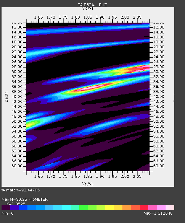
| Estimated Moho Depth: |
36.25 km |
| Estimated Crust Vp/Vs: |
1.85 |
| Assumed Crust Vp: |
6.61 km/s |
| Estimated Crust Vs: |
3.568 km/s |
| Estimated Crust Poisson's Ratio: |
0.29 |
|
| Radial Match: |
93.44795 % |
| Radial Bump: |
187 |
| Transverse Match: |
65.9268 % |
| Transverse Bump: |
400 |
| SOD ConfigId: |
626651 |
| Insert Time: |
2014-05-24 08:38:37.434 +0000 |
| GWidth: |
2.5 |
| Max Bumps: |
400 |
| Tol: |
0.001 |
|
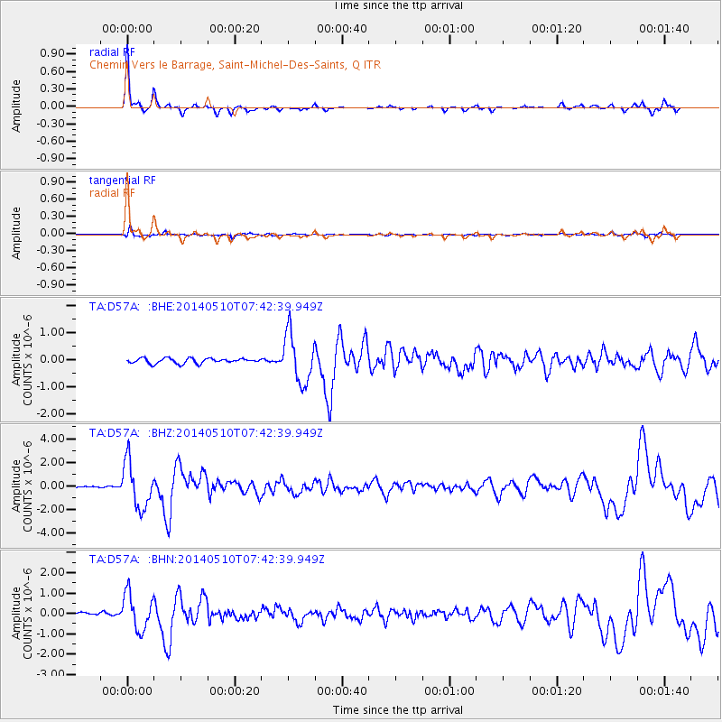
Signal To Noise
| Channel | StoN | STA | LTA |
| TA:D57A: :BHZ:20140510T07:42:39.949Z | 25.989641 | 1.9513234E-6 | 7.508081E-8 |
| TA:D57A: :BHN:20140510T07:42:39.949Z | 14.20244 | 8.948298E-7 | 6.300535E-8 |
| TA:D57A: :BHE:20140510T07:42:39.949Z | 9.830227 | 9.099254E-7 | 9.2564036E-8 |
| Arrivals |
| Ps | 5.0 SECOND |
| PpPs | 15 SECOND |
| PsPs/PpSs | 20 SECOND |


