You are here: Home > Network List > TA - USArray Transportable Network (new EarthScope stations) Stations List
> Station E50A Wahnapitae, ON, CAN > Earthquake Result Viewer
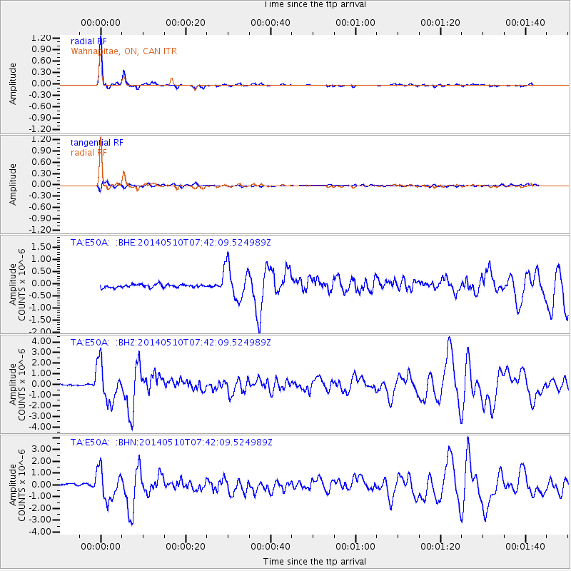
E50A Wahnapitae, ON, CAN - Earthquake Result Viewer

| Earthquake location: |
Guerrero, Mexico |
| Earthquake latitude/longitude: |
17.3/-100.8 |
| Earthquake time(UTC): |
2014/05/10 (130) 07:36:03 GMT |
| Earthquake Depth: |
35 km |
| Earthquake Magnitude: |
6.0 MB |
| Earthquake Catalog/Contributor: |
NEIC PDE/NEIC COMCAT |
|
| Network: |
TA USArray Transportable Network (new EarthScope stations) |
| Station: |
E50A Wahnapitae, ON, CAN |
| Lat/Lon: |
46.42 N/80.74 W |
| Elevation: |
242 m |
|
| Distance: |
33.5 deg |
| Az: |
25.416 deg |
| Baz: |
216.358 deg |
| Ray Param: |
0.07812854 |
| Estimated Moho Depth: |
50.0 km |
| Estimated Crust Vp/Vs: |
1.65 |
| Assumed Crust Vp: |
6.467 km/s |
| Estimated Crust Vs: |
3.913 km/s |
| Estimated Crust Poisson's Ratio: |
0.21 |
|
| Radial Match: |
96.59242 % |
| Radial Bump: |
184 |
| Transverse Match: |
72.35812 % |
| Transverse Bump: |
400 |
| SOD ConfigId: |
626651 |
| Insert Time: |
2014-05-24 08:39:16.829 +0000 |
| GWidth: |
2.5 |
| Max Bumps: |
400 |
| Tol: |
0.001 |
|
Signal To Noise
| Channel | StoN | STA | LTA |
| TA:E50A: :BHZ:20140510T07:42:09.524989Z | 23.18537 | 1.7813478E-6 | 7.683069E-8 |
| TA:E50A: :BHN:20140510T07:42:09.524989Z | 14.444636 | 1.2834613E-6 | 8.885383E-8 |
| TA:E50A: :BHE:20140510T07:42:09.524989Z | 11.108686 | 7.000407E-7 | 6.301742E-8 |
| Arrivals |
| Ps | 5.5 SECOND |
| PpPs | 19 SECOND |
| PsPs/PpSs | 24 SECOND |


