You are here: Home > Network List > TA - USArray Transportable Network (new EarthScope stations) Stations List
> Station E51A G1948 Merrick Township, ON, CAN > Earthquake Result Viewer
E51A G1948 Merrick Township, ON, CAN - Earthquake Result Viewer
| Earthquake location: |
Guerrero, Mexico |
| Earthquake latitude/longitude: |
17.3/-100.8 |
| Earthquake time(UTC): |
2014/05/10 (130) 07:36:03 GMT |
| Earthquake Depth: |
35 km |
| Earthquake Magnitude: |
6.0 MB |
| Earthquake Catalog/Contributor: |
NEIC PDE/NEIC COMCAT |
|
| Network: |
TA USArray Transportable Network (new EarthScope stations) |
| Station: |
E51A G1948 Merrick Township, ON, CAN |
| Lat/Lon: |
46.53 N/79.49 W |
| Elevation: |
369 m |
|
| Distance: |
34.1 deg |
| Az: |
26.527 deg |
| Baz: |
218.182 deg |
| Ray Param: |
0.07784847 |
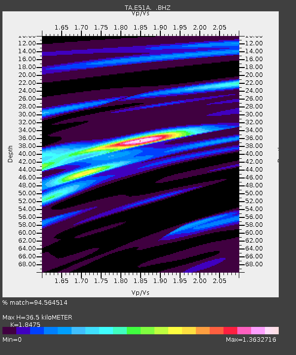
| Estimated Moho Depth: |
36.5 km |
| Estimated Crust Vp/Vs: |
1.85 |
| Assumed Crust Vp: |
6.622 km/s |
| Estimated Crust Vs: |
3.584 km/s |
| Estimated Crust Poisson's Ratio: |
0.29 |
|
| Radial Match: |
94.564514 % |
| Radial Bump: |
197 |
| Transverse Match: |
72.79647 % |
| Transverse Bump: |
400 |
| SOD ConfigId: |
626651 |
| Insert Time: |
2014-05-24 08:39:21.089 +0000 |
| GWidth: |
2.5 |
| Max Bumps: |
400 |
| Tol: |
0.001 |
|

Signal To Noise
| Channel | StoN | STA | LTA |
| TA:E51A: :BHZ:20140510T07:42:14.800013Z | 38.48172 | 2.1672645E-6 | 5.6319326E-8 |
| TA:E51A: :BHN:20140510T07:42:14.800013Z | 20.404007 | 1.2623991E-6 | 6.187016E-8 |
| TA:E51A: :BHE:20140510T07:42:14.800013Z | 23.136776 | 9.508158E-7 | 4.109543E-8 |
| Arrivals |
| Ps | 5.1 SECOND |
| PpPs | 15 SECOND |
| PsPs/PpSs | 20 SECOND |


