You are here: Home > Network List > TA - USArray Transportable Network (new EarthScope stations) Stations List
> Station E55A Montcerf-Lytton, QC, CAN > Earthquake Result Viewer
E55A Montcerf-Lytton, QC, CAN - Earthquake Result Viewer

| Earthquake location: |
Guerrero, Mexico |
| Earthquake latitude/longitude: |
17.3/-100.8 |
| Earthquake time(UTC): |
2014/05/10 (130) 07:36:03 GMT |
| Earthquake Depth: |
35 km |
| Earthquake Magnitude: |
6.0 MB |
| Earthquake Catalog/Contributor: |
NEIC PDE/NEIC COMCAT |
|
| Network: |
TA USArray Transportable Network (new EarthScope stations) |
| Station: |
E55A Montcerf-Lytton, QC, CAN |
| Lat/Lon: |
46.45 N/76.06 W |
| Elevation: |
180 m |
|
| Distance: |
35.6 deg |
| Az: |
29.765 deg |
| Baz: |
223.324 deg |
| Ray Param: |
0.0770792 |
| Estimated Moho Depth: |
29.25 km |
| Estimated Crust Vp/Vs: |
2.09 |
| Assumed Crust Vp: |
6.622 km/s |
| Estimated Crust Vs: |
3.176 km/s |
| Estimated Crust Poisson's Ratio: |
0.35 |
|
| Radial Match: |
95.65203 % |
| Radial Bump: |
240 |
| Transverse Match: |
81.85883 % |
| Transverse Bump: |
369 |
| SOD ConfigId: |
626651 |
| Insert Time: |
2014-05-24 08:39:35.403 +0000 |
| GWidth: |
2.5 |
| Max Bumps: |
400 |
| Tol: |
0.001 |
|
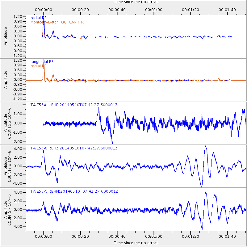
Signal To Noise
| Channel | StoN | STA | LTA |
| TA:E55A: :BHZ:20140510T07:42:27.600001Z | 20.07728 | 1.7623431E-6 | 8.777798E-8 |
| TA:E55A: :BHN:20140510T07:42:27.600001Z | 7.931297 | 8.8558403E-7 | 1.116569E-7 |
| TA:E55A: :BHE:20140510T07:42:27.600001Z | 6.6319127 | 7.832077E-7 | 1.180968E-7 |
| Arrivals |
| Ps | 5.1 SECOND |
| PpPs | 13 SECOND |
| PsPs/PpSs | 18 SECOND |


