You are here: Home > Network List > TA - USArray Transportable Network (new EarthScope stations) Stations List
> Station F57A Harrington, QC, CAN > Earthquake Result Viewer
F57A Harrington, QC, CAN - Earthquake Result Viewer
| Earthquake location: |
Guerrero, Mexico |
| Earthquake latitude/longitude: |
17.3/-100.8 |
| Earthquake time(UTC): |
2014/05/10 (130) 07:36:03 GMT |
| Earthquake Depth: |
35 km |
| Earthquake Magnitude: |
6.0 MB |
| Earthquake Catalog/Contributor: |
NEIC PDE/NEIC COMCAT |
|
| Network: |
TA USArray Transportable Network (new EarthScope stations) |
| Station: |
F57A Harrington, QC, CAN |
| Lat/Lon: |
45.81 N/74.69 W |
| Elevation: |
178 m |
|
| Distance: |
35.8 deg |
| Az: |
31.696 deg |
| Baz: |
225.872 deg |
| Ray Param: |
0.076965705 |
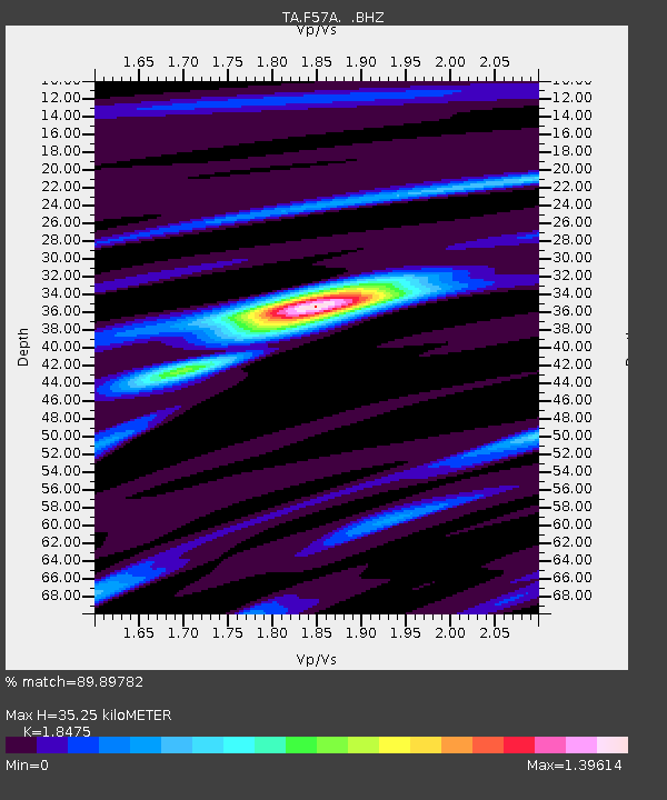
| Estimated Moho Depth: |
35.25 km |
| Estimated Crust Vp/Vs: |
1.85 |
| Assumed Crust Vp: |
6.419 km/s |
| Estimated Crust Vs: |
3.475 km/s |
| Estimated Crust Poisson's Ratio: |
0.29 |
|
| Radial Match: |
89.89782 % |
| Radial Bump: |
270 |
| Transverse Match: |
53.697624 % |
| Transverse Bump: |
400 |
| SOD ConfigId: |
626651 |
| Insert Time: |
2014-05-24 08:40:42.991 +0000 |
| GWidth: |
2.5 |
| Max Bumps: |
400 |
| Tol: |
0.001 |
|

Signal To Noise
| Channel | StoN | STA | LTA |
| TA:F57A: :BHZ:20140510T07:42:29.399012Z | 15.2923765 | 1.827748E-6 | 1.195202E-7 |
| TA:F57A: :BHN:20140510T07:42:29.399012Z | 19.2027 | 2.3891948E-6 | 1.2441973E-7 |
| TA:F57A: :BHE:20140510T07:42:29.399012Z | 8.611798 | 1.3928486E-6 | 1.6173726E-7 |
| Arrivals |
| Ps | 5.0 SECOND |
| PpPs | 15 SECOND |
| PsPs/PpSs | 20 SECOND |


