You are here: Home > Network List > TA - USArray Transportable Network (new EarthScope stations) Stations List
> Station F61A St Evariste, QC, CAN > Earthquake Result Viewer
F61A St Evariste, QC, CAN - Earthquake Result Viewer
| Earthquake location: |
Guerrero, Mexico |
| Earthquake latitude/longitude: |
17.3/-100.8 |
| Earthquake time(UTC): |
2014/05/10 (130) 07:36:03 GMT |
| Earthquake Depth: |
35 km |
| Earthquake Magnitude: |
6.0 MB |
| Earthquake Catalog/Contributor: |
NEIC PDE/NEIC COMCAT |
|
| Network: |
TA USArray Transportable Network (new EarthScope stations) |
| Station: |
F61A St Evariste, QC, CAN |
| Lat/Lon: |
45.97 N/70.99 W |
| Elevation: |
350 m |
|
| Distance: |
37.8 deg |
| Az: |
34.365 deg |
| Baz: |
230.659 deg |
| Ray Param: |
0.075844556 |
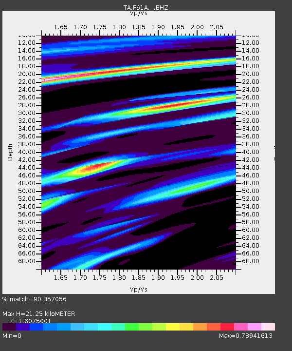
| Estimated Moho Depth: |
21.25 km |
| Estimated Crust Vp/Vs: |
1.61 |
| Assumed Crust Vp: |
6.419 km/s |
| Estimated Crust Vs: |
3.993 km/s |
| Estimated Crust Poisson's Ratio: |
0.18 |
|
| Radial Match: |
90.357056 % |
| Radial Bump: |
238 |
| Transverse Match: |
61.17842 % |
| Transverse Bump: |
400 |
| SOD ConfigId: |
626651 |
| Insert Time: |
2014-05-24 08:40:57.712 +0000 |
| GWidth: |
2.5 |
| Max Bumps: |
400 |
| Tol: |
0.001 |
|
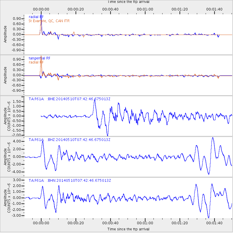
Signal To Noise
| Channel | StoN | STA | LTA |
| TA:F61A: :BHZ:20140510T07:42:46.675013Z | 18.48578 | 2.2353483E-6 | 1.2092259E-7 |
| TA:F61A: :BHN:20140510T07:42:46.675013Z | 9.41477 | 1.0461995E-6 | 1.11123214E-7 |
| TA:F61A: :BHE:20140510T07:42:46.675013Z | 12.948501 | 9.252551E-7 | 7.145654E-8 |
| Arrivals |
| Ps | 2.2 SECOND |
| PpPs | 8.0 SECOND |
| PsPs/PpSs | 10 SECOND |


