You are here: Home > Network List > TA - USArray Transportable Network (new EarthScope stations) Stations List
> Station F64A Sherman, ME, USA > Earthquake Result Viewer
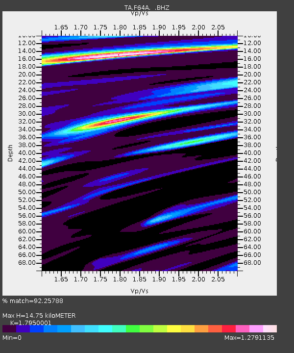
F64A Sherman, ME, USA - Earthquake Result Viewer
| Earthquake location: |
Guerrero, Mexico |
| Earthquake latitude/longitude: |
17.3/-100.8 |
| Earthquake time(UTC): |
2014/05/10 (130) 07:36:03 GMT |
| Earthquake Depth: |
35 km |
| Earthquake Magnitude: |
6.0 MB |
| Earthquake Catalog/Contributor: |
NEIC PDE/NEIC COMCAT |
|
| Network: |
TA USArray Transportable Network (new EarthScope stations) |
| Station: |
F64A Sherman, ME, USA |
| Lat/Lon: |
45.86 N/68.35 W |
| Elevation: |
179 m |
|
| Distance: |
39.2 deg |
| Az: |
36.315 deg |
| Baz: |
234.077 deg |
| Ray Param: |
0.07504038 |
| Estimated Moho Depth: |
14.75 km |
| Estimated Crust Vp/Vs: |
1.80 |
| Assumed Crust Vp: |
6.419 km/s |
| Estimated Crust Vs: |
3.576 km/s |
| Estimated Crust Poisson's Ratio: |
0.27 |
|
| Radial Match: |
92.25788 % |
| Radial Bump: |
279 |
| Transverse Match: |
76.98432 % |
| Transverse Bump: |
400 |
| SOD ConfigId: |
626651 |
| Insert Time: |
2014-05-24 08:41:05.758 +0000 |
| GWidth: |
2.5 |
| Max Bumps: |
400 |
| Tol: |
0.001 |
|

Signal To Noise
| Channel | StoN | STA | LTA |
| TA:F64A: :BHZ:20140510T07:42:58.374995Z | 38.0945 | 2.883597E-6 | 7.569588E-8 |
| TA:F64A: :BHN:20140510T07:42:58.374995Z | 13.938024 | 1.073158E-6 | 7.699499E-8 |
| TA:F64A: :BHE:20140510T07:42:58.374995Z | 14.410836 | 1.1061737E-6 | 7.675986E-8 |
| Arrivals |
| Ps | 2.0 SECOND |
| PpPs | 6.0 SECOND |
| PsPs/PpSs | 7.9 SECOND |


