You are here: Home > Network List > TA - USArray Transportable Network (new EarthScope stations) Stations List
> Station G46A Petoskey, MI, USA > Earthquake Result Viewer
G46A Petoskey, MI, USA - Earthquake Result Viewer
| Earthquake location: |
Guerrero, Mexico |
| Earthquake latitude/longitude: |
17.3/-100.8 |
| Earthquake time(UTC): |
2014/05/10 (130) 07:36:03 GMT |
| Earthquake Depth: |
35 km |
| Earthquake Magnitude: |
6.0 MB |
| Earthquake Catalog/Contributor: |
NEIC PDE/NEIC COMCAT |
|
| Network: |
TA USArray Transportable Network (new EarthScope stations) |
| Station: |
G46A Petoskey, MI, USA |
| Lat/Lon: |
45.32 N/84.86 W |
| Elevation: |
239 m |
|
| Distance: |
31.0 deg |
| Az: |
22.05 deg |
| Baz: |
210.559 deg |
| Ray Param: |
0.0791581 |
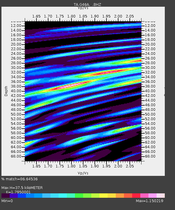
| Estimated Moho Depth: |
37.5 km |
| Estimated Crust Vp/Vs: |
1.80 |
| Assumed Crust Vp: |
6.483 km/s |
| Estimated Crust Vs: |
3.611 km/s |
| Estimated Crust Poisson's Ratio: |
0.27 |
|
| Radial Match: |
86.64536 % |
| Radial Bump: |
400 |
| Transverse Match: |
53.590916 % |
| Transverse Bump: |
400 |
| SOD ConfigId: |
626651 |
| Insert Time: |
2014-05-24 08:41:22.851 +0000 |
| GWidth: |
2.5 |
| Max Bumps: |
400 |
| Tol: |
0.001 |
|

Signal To Noise
| Channel | StoN | STA | LTA |
| TA:G46A: :BHZ:20140510T07:41:47.550013Z | 10.976733 | 1.854023E-6 | 1.689048E-7 |
| TA:G46A: :BHN:20140510T07:41:47.550013Z | 4.5405345 | 1.206054E-6 | 2.6561938E-7 |
| TA:G46A: :BHE:20140510T07:41:47.550013Z | 2.8410478 | 8.8786925E-7 | 3.1251471E-7 |
| Arrivals |
| Ps | 5.0 SECOND |
| PpPs | 15 SECOND |
| PsPs/PpSs | 20 SECOND |


