You are here: Home > Network List > TA - USArray Transportable Network (new EarthScope stations) Stations List
> Station G62A West of Eustis, ME, USA > Earthquake Result Viewer
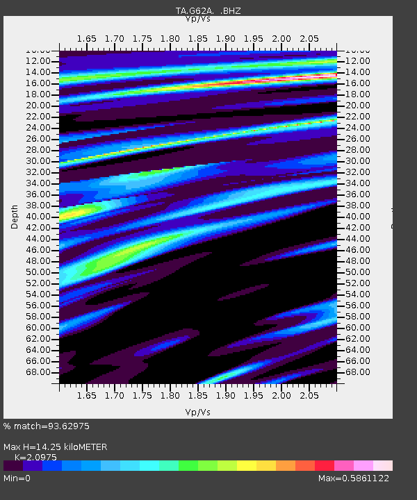
G62A West of Eustis, ME, USA - Earthquake Result Viewer
| Earthquake location: |
Guerrero, Mexico |
| Earthquake latitude/longitude: |
17.3/-100.8 |
| Earthquake time(UTC): |
2014/05/10 (130) 07:36:03 GMT |
| Earthquake Depth: |
35 km |
| Earthquake Magnitude: |
6.0 MB |
| Earthquake Catalog/Contributor: |
NEIC PDE/NEIC COMCAT |
|
| Network: |
TA USArray Transportable Network (new EarthScope stations) |
| Station: |
G62A West of Eustis, ME, USA |
| Lat/Lon: |
45.22 N/70.53 W |
| Elevation: |
426 m |
|
| Distance: |
37.6 deg |
| Az: |
35.66 deg |
| Baz: |
232.011 deg |
| Ray Param: |
0.075972214 |
| Estimated Moho Depth: |
14.25 km |
| Estimated Crust Vp/Vs: |
2.10 |
| Assumed Crust Vp: |
6.419 km/s |
| Estimated Crust Vs: |
3.06 km/s |
| Estimated Crust Poisson's Ratio: |
0.35 |
|
| Radial Match: |
93.62975 % |
| Radial Bump: |
287 |
| Transverse Match: |
83.912895 % |
| Transverse Bump: |
400 |
| SOD ConfigId: |
626651 |
| Insert Time: |
2014-05-24 08:41:59.153 +0000 |
| GWidth: |
2.5 |
| Max Bumps: |
400 |
| Tol: |
0.001 |
|

Signal To Noise
| Channel | StoN | STA | LTA |
| TA:G62A: :BHZ:20140510T07:42:44.824Z | 32.50236 | 2.9227813E-6 | 8.9925194E-8 |
| TA:G62A: :BHN:20140510T07:42:44.824Z | 17.862879 | 1.2435909E-6 | 6.961872E-8 |
| TA:G62A: :BHE:20140510T07:42:44.824Z | 15.629977 | 1.2413815E-6 | 7.942311E-8 |
| Arrivals |
| Ps | 2.6 SECOND |
| PpPs | 6.5 SECOND |
| PsPs/PpSs | 9.1 SECOND |


