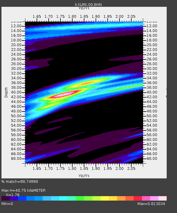
KURK Kurchatov, Kazakhstan - Earthquake Result Viewer

Earthquake location: Talaud Islands, Indonesia
Earthquake latitude/longitude: 3.9/126.4
Earthquake time(UTC): 2009/02/11 (042) 17:34:50 GMT
Earthquake Depth: 22 km
Earthquake Magnitude: 6.6 MB, 7.2 MS, 7.2 MW, 7.1 MW
Earthquake Catalog/Contributor: WHDF/NEIC
Network: II Global Seismograph Network (GSN - IRIS/IDA)
Station: KURK Kurchatov, Kazakhstan
Lat/Lon: 50.72 N/78.62 E
Elevation: 184 m
Distance: 61.4 deg
Az: 327.586 deg
Baz: 122.725 deg
Ray Param: 0.060849752
Estimated Moho Depth: 40.75 km
Estimated Crust Vp/Vs: 1.76
Assumed Crust Vp: 6.552 km/s
Estimated Crust Vs: 3.723 km/s
Estimated Crust Poisson's Ratio: 0.26
Radial Match: 98.74998 %
Radial Bump: 235
Transverse Match: 94.174736 %
Transverse Bump: 400
SOD ConfigId: 2658
Insert Time: 2010-03-01 21:59:16.278 +0000
GWidth: 2.5
Max Bumps: 400
Tol: 0.001

Signal To Noise

ChannelStoNSTALTA
II:KURK:00:BHN:20090211T17:44:34.352002Z37.7322542.662328E-67.055841E-8
II:KURK:00:BHE:20090211T17:44:34.352002Z11.8044716.594989E-75.586857E-8
II:KURK:00:BHZ:20090211T17:44:34.352002Z14.3398719.946084E-76.935964E-8
Arrivals
Ps5.0 SECOND
PpPs16 SECOND
PsPs/PpSs21 SECOND