You are here: Home > Network List > TA - USArray Transportable Network (new EarthScope stations) Stations List
> Station I60A Shoreham, VT, USA > Earthquake Result Viewer
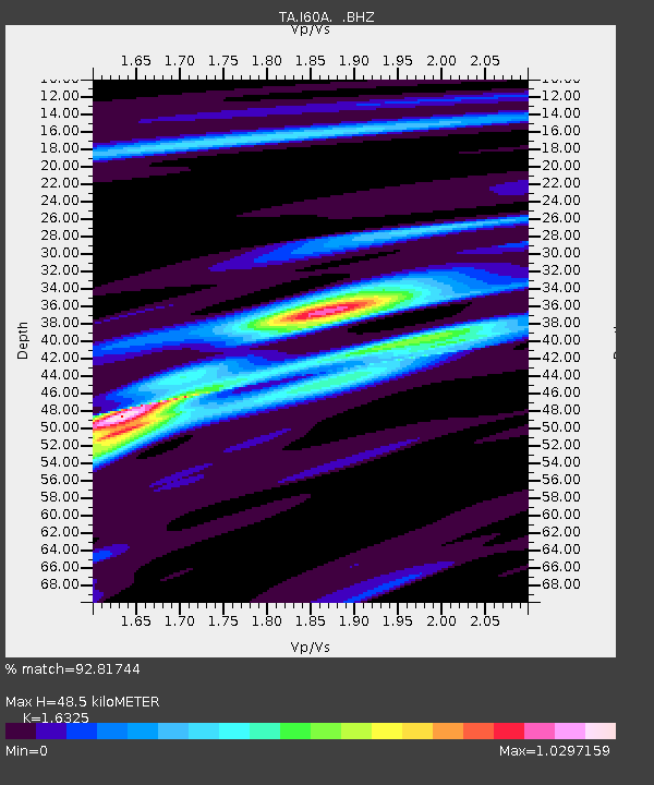
I60A Shoreham, VT, USA - Earthquake Result Viewer
| Earthquake location: |
Guerrero, Mexico |
| Earthquake latitude/longitude: |
17.3/-100.8 |
| Earthquake time(UTC): |
2014/05/10 (130) 07:36:03 GMT |
| Earthquake Depth: |
35 km |
| Earthquake Magnitude: |
6.0 MB |
| Earthquake Catalog/Contributor: |
NEIC PDE/NEIC COMCAT |
|
| Network: |
TA USArray Transportable Network (new EarthScope stations) |
| Station: |
I60A Shoreham, VT, USA |
| Lat/Lon: |
43.84 N/73.29 W |
| Elevation: |
101 m |
|
| Distance: |
35.2 deg |
| Az: |
35.361 deg |
| Baz: |
229.841 deg |
| Ray Param: |
0.07727844 |
| Estimated Moho Depth: |
48.5 km |
| Estimated Crust Vp/Vs: |
1.63 |
| Assumed Crust Vp: |
6.419 km/s |
| Estimated Crust Vs: |
3.932 km/s |
| Estimated Crust Poisson's Ratio: |
0.20 |
|
| Radial Match: |
92.81744 % |
| Radial Bump: |
306 |
| Transverse Match: |
73.24744 % |
| Transverse Bump: |
400 |
| SOD ConfigId: |
626651 |
| Insert Time: |
2014-05-24 08:44:46.719 +0000 |
| GWidth: |
2.5 |
| Max Bumps: |
400 |
| Tol: |
0.001 |
|

Signal To Noise
| Channel | StoN | STA | LTA |
| TA:I60A: :BHZ:20140510T07:42:24.425013Z | 34.191563 | 2.0332166E-6 | 5.9465453E-8 |
| TA:I60A: :BHN:20140510T07:42:24.425013Z | 10.133769 | 7.648943E-7 | 7.547974E-8 |
| TA:I60A: :BHE:20140510T07:42:24.425013Z | 6.22403 | 1.1438112E-6 | 1.8377341E-7 |
| Arrivals |
| Ps | 5.2 SECOND |
| PpPs | 18 SECOND |
| PsPs/PpSs | 24 SECOND |


