You are here: Home > Network List > TA - USArray Transportable Network (new EarthScope stations) Stations List
> Station J05D Fort Rock, OR, USA > Earthquake Result Viewer
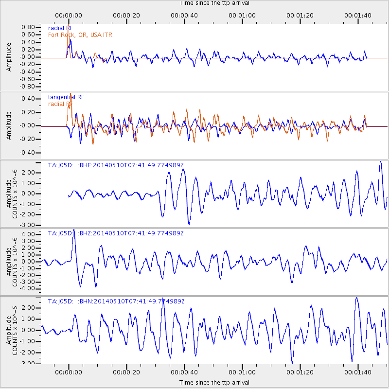
J05D Fort Rock, OR, USA - Earthquake Result Viewer
*The percent match for this event was below the threshold and hence no stack was calculated.
| Earthquake location: |
Guerrero, Mexico |
| Earthquake latitude/longitude: |
17.3/-100.8 |
| Earthquake time(UTC): |
2014/05/10 (130) 07:36:03 GMT |
| Earthquake Depth: |
35 km |
| Earthquake Magnitude: |
6.0 MB |
| Earthquake Catalog/Contributor: |
NEIC PDE/NEIC COMCAT |
|
| Network: |
TA USArray Transportable Network (new EarthScope stations) |
| Station: |
J05D Fort Rock, OR, USA |
| Lat/Lon: |
43.28 N/121.23 W |
| Elevation: |
1541 m |
|
| Distance: |
31.2 deg |
| Az: |
330.468 deg |
| Baz: |
139.837 deg |
| Ray Param: |
$rayparam |
*The percent match for this event was below the threshold and hence was not used in the summary stack. |
|
| Radial Match: |
56.956573 % |
| Radial Bump: |
400 |
| Transverse Match: |
72.43879 % |
| Transverse Bump: |
400 |
| SOD ConfigId: |
626651 |
| Insert Time: |
2014-05-24 08:45:18.787 +0000 |
| GWidth: |
2.5 |
| Max Bumps: |
400 |
| Tol: |
0.001 |
|
Signal To Noise
| Channel | StoN | STA | LTA |
| TA:J05D: :BHZ:20140510T07:41:49.774989Z | 12.764701 | 2.3392145E-6 | 1.8325649E-7 |
| TA:J05D: :BHN:20140510T07:41:49.774989Z | 2.604376 | 7.312876E-7 | 2.8079185E-7 |
| TA:J05D: :BHE:20140510T07:41:49.774989Z | 5.629372 | 1.2413041E-6 | 2.2050489E-7 |
| Arrivals |
| Ps | |
| PpPs | |
| PsPs/PpSs | |


