You are here: Home > Network List > TA - USArray Transportable Network (new EarthScope stations) Stations List
> Station L04D Klamath Falls, OR, USA > Earthquake Result Viewer
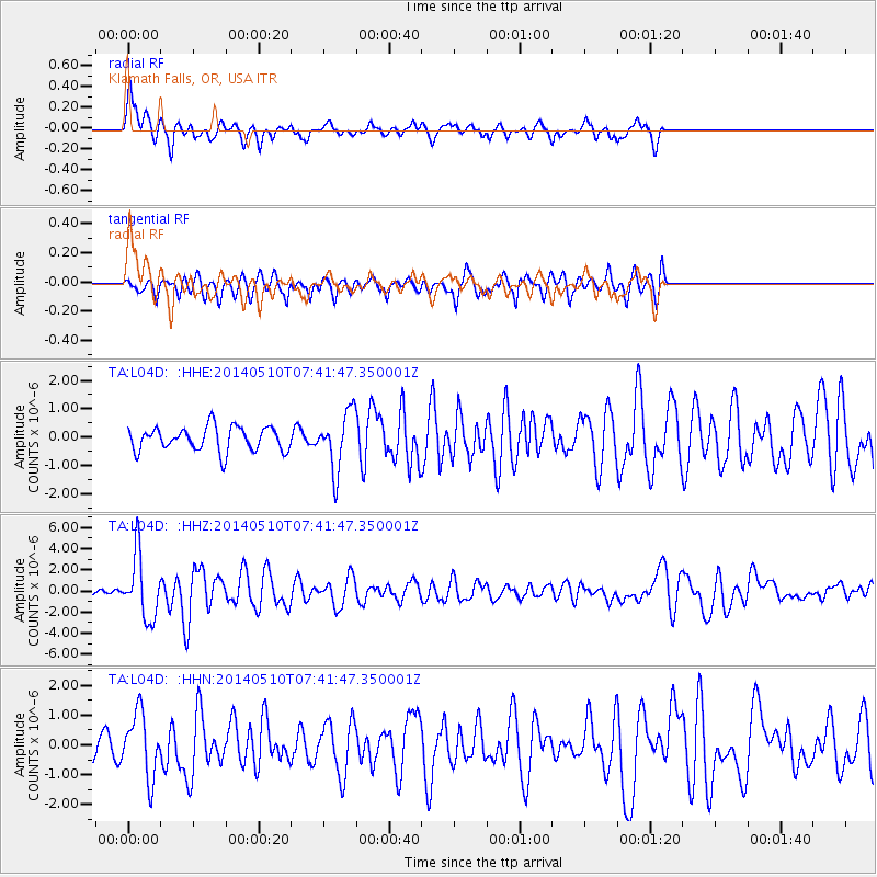
L04D Klamath Falls, OR, USA - Earthquake Result Viewer

| Earthquake location: |
Guerrero, Mexico |
| Earthquake latitude/longitude: |
17.3/-100.8 |
| Earthquake time(UTC): |
2014/05/10 (130) 07:36:03 GMT |
| Earthquake Depth: |
35 km |
| Earthquake Magnitude: |
6.0 MB |
| Earthquake Catalog/Contributor: |
NEIC PDE/NEIC COMCAT |
|
| Network: |
TA USArray Transportable Network (new EarthScope stations) |
| Station: |
L04D Klamath Falls, OR, USA |
| Lat/Lon: |
42.22 N/122.30 W |
| Elevation: |
1437 m |
|
| Distance: |
30.9 deg |
| Az: |
327.955 deg |
| Baz: |
136.961 deg |
| Ray Param: |
0.0791642 |
| Estimated Moho Depth: |
14.5 km |
| Estimated Crust Vp/Vs: |
1.61 |
| Assumed Crust Vp: |
6.522 km/s |
| Estimated Crust Vs: |
4.063 km/s |
| Estimated Crust Poisson's Ratio: |
0.18 |
|
| Radial Match: |
83.20056 % |
| Radial Bump: |
355 |
| Transverse Match: |
54.452175 % |
| Transverse Bump: |
383 |
| SOD ConfigId: |
626651 |
| Insert Time: |
2014-05-24 08:47:07.787 +0000 |
| GWidth: |
2.5 |
| Max Bumps: |
400 |
| Tol: |
0.001 |
|
Signal To Noise
| Channel | StoN | STA | LTA |
| TA:L04D: :HHZ:20140510T07:41:47.350001Z | 8.541191 | 2.9551268E-6 | 3.459853E-7 |
| TA:L04D: :HHN:20140510T07:41:47.350001Z | 3.3574069 | 1.073422E-6 | 3.197176E-7 |
| TA:L04D: :HHE:20140510T07:41:47.350001Z | 2.3610668 | 1.0056301E-6 | 4.259219E-7 |
| Arrivals |
| Ps | 1.5 SECOND |
| PpPs | 5.3 SECOND |
| PsPs/PpSs | 6.8 SECOND |


