You are here: Home > Network List > II - Global Seismograph Network (GSN - IRIS/IDA) Stations List
> Station KURK Kurchatov, Kazakhstan > Earthquake Result Viewer
KURK Kurchatov, Kazakhstan - Earthquake Result Viewer
| Earthquake location: |
Solomon Islands |
| Earthquake latitude/longitude: |
-10.5/160.8 |
| Earthquake time(UTC): |
2003/01/20 (020) 08:43:06 GMT |
| Earthquake Depth: |
33 km |
| Earthquake Magnitude: |
6.7 MB, 7.8 MS, 7.3 MW, 7.2 MW |
| Earthquake Catalog/Contributor: |
WHDF/NEIC |
|
| Network: |
II Global Seismograph Network (GSN - IRIS/IDA) |
| Station: |
KURK Kurchatov, Kazakhstan |
| Lat/Lon: |
50.72 N/78.62 E |
| Elevation: |
184 m |
|
| Distance: |
93.1 deg |
| Az: |
320.899 deg |
| Baz: |
102.651 deg |
| Ray Param: |
0.041314755 |
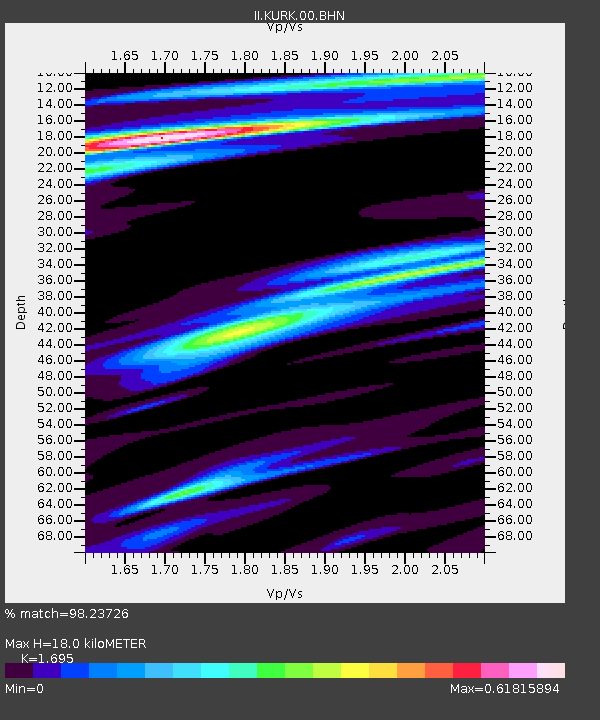
| Estimated Moho Depth: |
18.0 km |
| Estimated Crust Vp/Vs: |
1.70 |
| Assumed Crust Vp: |
6.552 km/s |
| Estimated Crust Vs: |
3.866 km/s |
| Estimated Crust Poisson's Ratio: |
0.23 |
|
| Radial Match: |
98.23726 % |
| Radial Bump: |
282 |
| Transverse Match: |
93.39709 % |
| Transverse Bump: |
400 |
| SOD ConfigId: |
4714 |
| Insert Time: |
2010-03-01 21:59:53.906 +0000 |
| GWidth: |
2.5 |
| Max Bumps: |
400 |
| Tol: |
0.001 |
|
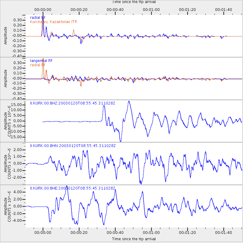
Signal To Noise
| Channel | StoN | STA | LTA |
| II:KURK:00:BHN:20030120T08:55:45.311028Z | 2.5607326 | 5.307807E-7 | 2.0727691E-7 |
| II:KURK:00:BHE:20030120T08:55:45.311028Z | 21.838543 | 1.8399979E-6 | 8.425461E-8 |
| II:KURK:00:BHZ:20030120T08:55:45.311028Z | 34.62245 | 6.4786736E-6 | 1.8712349E-7 |
| Arrivals |
| Ps | 2.0 SECOND |
| PpPs | 7.2 SECOND |
| PsPs/PpSs | 9.2 SECOND |


