You are here: Home > Network List > TA - USArray Transportable Network (new EarthScope stations) Stations List
> Station M61A Granite Springs, NY, USA > Earthquake Result Viewer
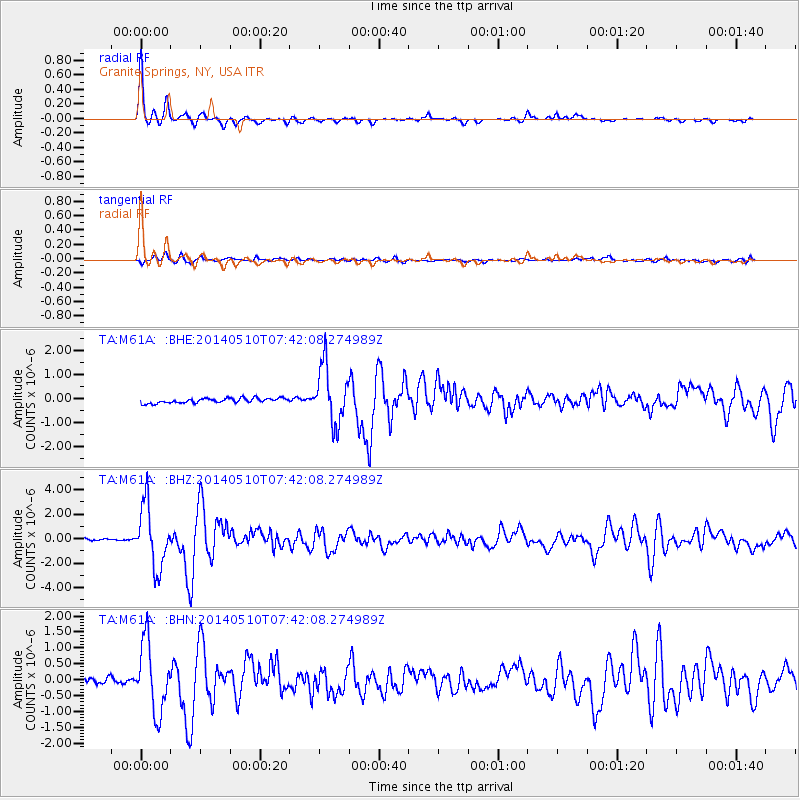
M61A Granite Springs, NY, USA - Earthquake Result Viewer

| Earthquake location: |
Guerrero, Mexico |
| Earthquake latitude/longitude: |
17.3/-100.8 |
| Earthquake time(UTC): |
2014/05/10 (130) 07:36:03 GMT |
| Earthquake Depth: |
35 km |
| Earthquake Magnitude: |
6.0 MB |
| Earthquake Catalog/Contributor: |
NEIC PDE/NEIC COMCAT |
|
| Network: |
TA USArray Transportable Network (new EarthScope stations) |
| Station: |
M61A Granite Springs, NY, USA |
| Lat/Lon: |
41.31 N/73.77 W |
| Elevation: |
190 m |
|
| Distance: |
33.3 deg |
| Az: |
38.46 deg |
| Baz: |
232.082 deg |
| Ray Param: |
0.07819395 |
| Estimated Moho Depth: |
22.25 km |
| Estimated Crust Vp/Vs: |
2.10 |
| Assumed Crust Vp: |
6.472 km/s |
| Estimated Crust Vs: |
3.086 km/s |
| Estimated Crust Poisson's Ratio: |
0.35 |
|
| Radial Match: |
96.0163 % |
| Radial Bump: |
252 |
| Transverse Match: |
75.94885 % |
| Transverse Bump: |
400 |
| SOD ConfigId: |
626651 |
| Insert Time: |
2014-05-24 08:48:43.974 +0000 |
| GWidth: |
2.5 |
| Max Bumps: |
400 |
| Tol: |
0.001 |
|
Signal To Noise
| Channel | StoN | STA | LTA |
| TA:M61A: :BHZ:20140510T07:42:08.274989Z | 21.4834 | 2.5170289E-6 | 1.1716157E-7 |
| TA:M61A: :BHN:20140510T07:42:08.274989Z | 13.888226 | 1.0854375E-6 | 7.815523E-8 |
| TA:M61A: :BHE:20140510T07:42:08.274989Z | 11.927548 | 1.180608E-6 | 9.898161E-8 |
| Arrivals |
| Ps | 4.0 SECOND |
| PpPs | 10.0 SECOND |
| PsPs/PpSs | 14 SECOND |


