You are here: Home > Network List > TA - USArray Transportable Network (new EarthScope stations) Stations List
> Station O57A Amberson, PA, USA > Earthquake Result Viewer
O57A Amberson, PA, USA - Earthquake Result Viewer

| Earthquake location: |
Guerrero, Mexico |
| Earthquake latitude/longitude: |
17.3/-100.8 |
| Earthquake time(UTC): |
2014/05/10 (130) 07:36:03 GMT |
| Earthquake Depth: |
35 km |
| Earthquake Magnitude: |
6.0 MB |
| Earthquake Catalog/Contributor: |
NEIC PDE/NEIC COMCAT |
|
| Network: |
TA USArray Transportable Network (new EarthScope stations) |
| Station: |
O57A Amberson, PA, USA |
| Lat/Lon: |
40.21 N/77.64 W |
| Elevation: |
377 m |
|
| Distance: |
30.4 deg |
| Az: |
36.475 deg |
| Baz: |
227.879 deg |
| Ray Param: |
0.07931232 |
| Estimated Moho Depth: |
31.25 km |
| Estimated Crust Vp/Vs: |
2.09 |
| Assumed Crust Vp: |
6.121 km/s |
| Estimated Crust Vs: |
2.932 km/s |
| Estimated Crust Poisson's Ratio: |
0.35 |
|
| Radial Match: |
92.95238 % |
| Radial Bump: |
400 |
| Transverse Match: |
72.44533 % |
| Transverse Bump: |
400 |
| SOD ConfigId: |
626651 |
| Insert Time: |
2014-05-24 08:49:58.156 +0000 |
| GWidth: |
2.5 |
| Max Bumps: |
400 |
| Tol: |
0.001 |
|
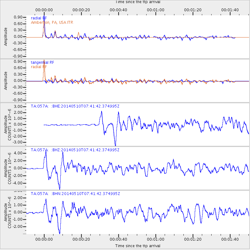
Signal To Noise
| Channel | StoN | STA | LTA |
| TA:O57A: :BHZ:20140510T07:41:42.374995Z | 37.957558 | 2.221096E-6 | 5.8515255E-8 |
| TA:O57A: :BHN:20140510T07:41:42.374995Z | 20.232464 | 9.538632E-7 | 4.714518E-8 |
| TA:O57A: :BHE:20140510T07:41:42.374995Z | 23.824314 | 1.0607149E-6 | 4.4522373E-8 |
| Arrivals |
| Ps | 5.9 SECOND |
| PpPs | 15 SECOND |
| PsPs/PpSs | 21 SECOND |


