You are here: Home > Network List > TA - USArray Transportable Network (new EarthScope stations) Stations List
> Station Q61A Milford, DE, USA > Earthquake Result Viewer
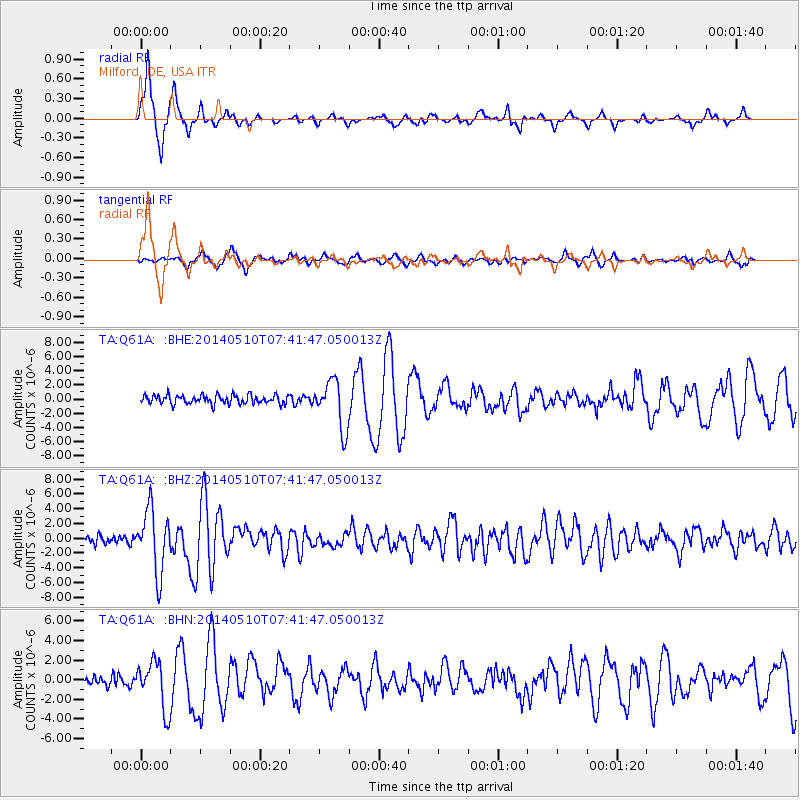
Q61A Milford, DE, USA - Earthquake Result Viewer
*The percent match for this event was below the threshold and hence no stack was calculated.
| Earthquake location: |
Guerrero, Mexico |
| Earthquake latitude/longitude: |
17.3/-100.8 |
| Earthquake time(UTC): |
2014/05/10 (130) 07:36:03 GMT |
| Earthquake Depth: |
35 km |
| Earthquake Magnitude: |
6.0 MB |
| Earthquake Catalog/Contributor: |
NEIC PDE/NEIC COMCAT |
|
| Network: |
TA USArray Transportable Network (new EarthScope stations) |
| Station: |
Q61A Milford, DE, USA |
| Lat/Lon: |
38.88 N/75.33 W |
| Elevation: |
5.0 m |
|
| Distance: |
30.9 deg |
| Az: |
40.716 deg |
| Baz: |
232.993 deg |
| Ray Param: |
$rayparam |
*The percent match for this event was below the threshold and hence was not used in the summary stack. |
|
| Radial Match: |
92.115776 % |
| Radial Bump: |
337 |
| Transverse Match: |
79.60167 % |
| Transverse Bump: |
400 |
| SOD ConfigId: |
626651 |
| Insert Time: |
2014-05-24 08:50:47.385 +0000 |
| GWidth: |
2.5 |
| Max Bumps: |
400 |
| Tol: |
0.001 |
|
Signal To Noise
| Channel | StoN | STA | LTA |
| TA:Q61A: :BHZ:20140510T07:41:47.050013Z | 7.392258 | 4.199355E-6 | 5.680747E-7 |
| TA:Q61A: :BHN:20140510T07:41:47.050013Z | 4.0272646 | 2.4782073E-6 | 6.153574E-7 |
| TA:Q61A: :BHE:20140510T07:41:47.050013Z | 5.523694 | 3.3957344E-6 | 6.147579E-7 |
| Arrivals |
| Ps | |
| PpPs | |
| PsPs/PpSs | |


