You are here: Home > Network List > US - United States National Seismic Network Stations List
> Station HAWA Hanford, Washington, USA > Earthquake Result Viewer
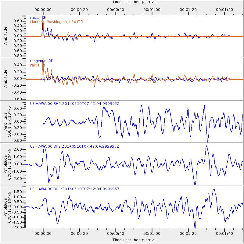
HAWA Hanford, Washington, USA - Earthquake Result Viewer
*The percent match for this event was below the threshold and hence no stack was calculated.
| Earthquake location: |
Guerrero, Mexico |
| Earthquake latitude/longitude: |
17.3/-100.8 |
| Earthquake time(UTC): |
2014/05/10 (130) 07:36:03 GMT |
| Earthquake Depth: |
35 km |
| Earthquake Magnitude: |
6.0 MB |
| Earthquake Catalog/Contributor: |
NEIC PDE/NEIC COMCAT |
|
| Network: |
US United States National Seismic Network |
| Station: |
HAWA Hanford, Washington, USA |
| Lat/Lon: |
46.39 N/119.53 W |
| Elevation: |
364 m |
|
| Distance: |
33.0 deg |
| Az: |
335.826 deg |
| Baz: |
145.574 deg |
| Ray Param: |
$rayparam |
*The percent match for this event was below the threshold and hence was not used in the summary stack. |
|
| Radial Match: |
73.5823 % |
| Radial Bump: |
400 |
| Transverse Match: |
67.97268 % |
| Transverse Bump: |
400 |
| SOD ConfigId: |
626651 |
| Insert Time: |
2014-05-24 08:51:56.905 +0000 |
| GWidth: |
2.5 |
| Max Bumps: |
400 |
| Tol: |
0.001 |
|
Signal To Noise
| Channel | StoN | STA | LTA |
| US:HAWA:00:BHZ:20140510T07:42:04.999995Z | 16.125679 | 1.6869614E-6 | 1.04613356E-7 |
| US:HAWA:00:BH1:20140510T07:42:04.999995Z | 5.4056525 | 6.0733026E-7 | 1.1235097E-7 |
| US:HAWA:00:BH2:20140510T07:42:04.999995Z | 4.9846916 | 5.177589E-7 | 1.03869795E-7 |
| Arrivals |
| Ps | |
| PpPs | |
| PsPs/PpSs | |


