You are here: Home > Network List > UW - Pacific Northwest Regional Seismic Network Stations List
> Station LON Longmire (broad-band and DWWSSN) > Earthquake Result Viewer
LON Longmire (broad-band and DWWSSN) - Earthquake Result Viewer
| Earthquake location: |
Guerrero, Mexico |
| Earthquake latitude/longitude: |
17.3/-100.8 |
| Earthquake time(UTC): |
2014/05/10 (130) 07:36:03 GMT |
| Earthquake Depth: |
35 km |
| Earthquake Magnitude: |
6.0 MB |
| Earthquake Catalog/Contributor: |
NEIC PDE/NEIC COMCAT |
|
| Network: |
UW Pacific Northwest Regional Seismic Network |
| Station: |
LON Longmire (broad-band and DWWSSN) |
| Lat/Lon: |
46.75 N/121.81 W |
| Elevation: |
850 m |
|
| Distance: |
34.2 deg |
| Az: |
333.909 deg |
| Baz: |
142.328 deg |
| Ray Param: |
0.077809826 |
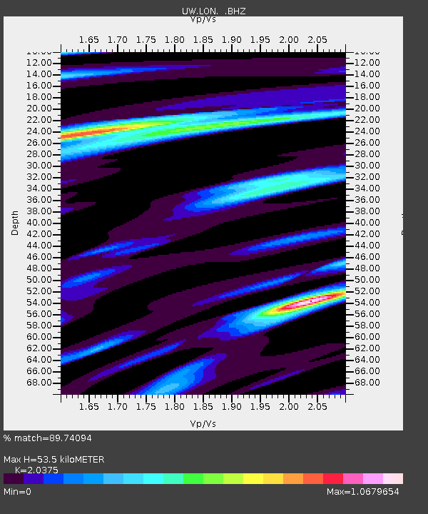
| Estimated Moho Depth: |
53.5 km |
| Estimated Crust Vp/Vs: |
2.04 |
| Assumed Crust Vp: |
6.597 km/s |
| Estimated Crust Vs: |
3.238 km/s |
| Estimated Crust Poisson's Ratio: |
0.34 |
|
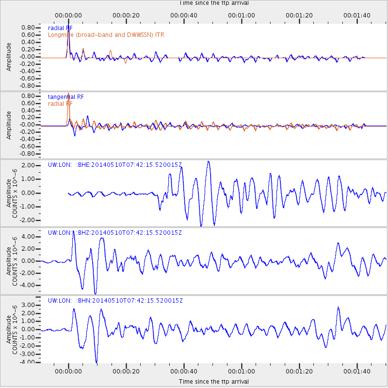
| Radial Match: |
89.74094 % |
| Radial Bump: |
329 |
| Transverse Match: |
82.532776 % |
| Transverse Bump: |
400 |
| SOD ConfigId: |
626651 |
| Insert Time: |
2014-05-24 08:54:02.834 +0000 |
| GWidth: |
2.5 |
| Max Bumps: |
400 |
| Tol: |
0.001 |
|
Signal To Noise
| Channel | StoN | STA | LTA |
| UW:LON: :BHZ:20140510T07:42:15.520015Z | 17.953371 | 2.4649637E-6 | 1.372981E-7 |
| UW:LON: :BHN:20140510T07:42:15.520015Z | 21.663763 | 1.4204155E-6 | 6.5566425E-8 |
| UW:LON: :BHE:20140510T07:42:15.520015Z | 5.6356816 | 4.987264E-7 | 8.8494424E-8 |
| Arrivals |
| Ps | 9.0 SECOND |
| PpPs | 23 SECOND |
| PsPs/PpSs | 32 SECOND |


