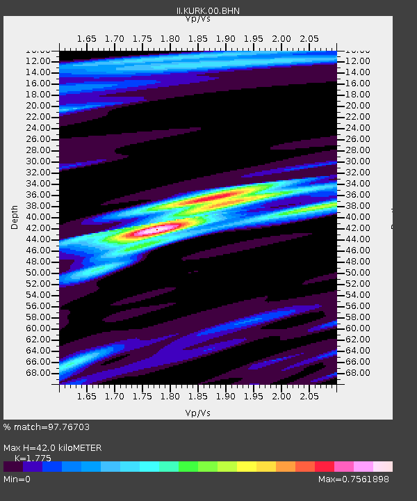
KURK Kurchatov, Kazakhstan - Earthquake Result Viewer

Earthquake location: Irian Jaya Region, Indonesia
Earthquake latitude/longitude: -3.7/135.3
Earthquake time(UTC): 2004/02/08 (039) 08:58:51 GMT
Earthquake Depth: 26 km
Earthquake Magnitude: 5.7 MB, 6.9 MS, 6.7 MW, 6.5 MW
Earthquake Catalog/Contributor: WHDF/NEIC
Network: II Global Seismograph Network (GSN - IRIS/IDA)
Station: KURK Kurchatov, Kazakhstan
Lat/Lon: 50.72 N/78.62 E
Elevation: 184 m
Distance: 72.6 deg
Az: 326.155 deg
Baz: 119.034 deg
Ray Param: 0.053525496
Estimated Moho Depth: 42.0 km
Estimated Crust Vp/Vs: 1.77
Assumed Crust Vp: 6.552 km/s
Estimated Crust Vs: 3.692 km/s
Estimated Crust Poisson's Ratio: 0.27
Radial Match: 97.76703 %
Radial Bump: 292
Transverse Match: 83.46079 %
Transverse Bump: 400
SOD ConfigId: 2459
Insert Time: 2010-03-01 22:01:55.247 +0000
GWidth: 2.5
Max Bumps: 400
Tol: 0.001

Signal To Noise

ChannelStoNSTALTA
II:KURK:00:BHN:20040208T09:09:45.643994Z3.65650321.8271716E-74.9970463E-8
II:KURK:00:BHE:20040208T09:09:45.643994Z4.5316393.2624922E-77.199365E-8
II:KURK:00:BHZ:20040208T09:09:45.643994Z12.3633389.2437506E-77.4767435E-8
Arrivals
Ps5.2 SECOND
PpPs17 SECOND
PsPs/PpSs22 SECOND