You are here: Home > Network List > TA - USArray Transportable Network (new EarthScope stations) Stations List
> Station N23A Red Feather Lakes, CO, USA > Earthquake Result Viewer
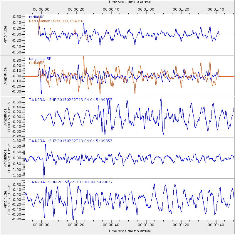
N23A Red Feather Lakes, CO, USA - Earthquake Result Viewer
*The percent match for this event was below the threshold and hence no stack was calculated.
| Earthquake location: |
Colombia |
| Earthquake latitude/longitude: |
2.7/-76.5 |
| Earthquake time(UTC): |
2015/02/22 (053) 12:56:24 GMT |
| Earthquake Depth: |
151 km |
| Earthquake Magnitude: |
5.6 MB |
| Earthquake Catalog/Contributor: |
NEIC PDE/NEIC COMCAT |
|
| Network: |
TA USArray Transportable Network (new EarthScope stations) |
| Station: |
N23A Red Feather Lakes, CO, USA |
| Lat/Lon: |
40.89 N/105.94 W |
| Elevation: |
2458 m |
|
| Distance: |
46.4 deg |
| Az: |
329.025 deg |
| Baz: |
137.299 deg |
| Ray Param: |
$rayparam |
*The percent match for this event was below the threshold and hence was not used in the summary stack. |
|
| Radial Match: |
51.877335 % |
| Radial Bump: |
379 |
| Transverse Match: |
53.770016 % |
| Transverse Bump: |
400 |
| SOD ConfigId: |
7019011 |
| Insert Time: |
2019-04-17 00:36:51.036 +0000 |
| GWidth: |
2.5 |
| Max Bumps: |
400 |
| Tol: |
0.001 |
|
Signal To Noise
| Channel | StoN | STA | LTA |
| TA:N23A: :BHZ:20150222T13:04:04.549985Z | 4.7748175 | 5.972688E-7 | 1.2508725E-7 |
| TA:N23A: :BHN:20150222T13:04:04.549985Z | 1.3322822 | 2.905084E-7 | 2.1805323E-7 |
| TA:N23A: :BHE:20150222T13:04:04.549985Z | 1.2791495 | 2.4714757E-7 | 1.9321241E-7 |
| Arrivals |
| Ps | |
| PpPs | |
| PsPs/PpSs | |


