You are here: Home > Network List > TA - USArray Transportable Network (new EarthScope stations) Stations List
> Station Q53A Leroy, WV, USA > Earthquake Result Viewer
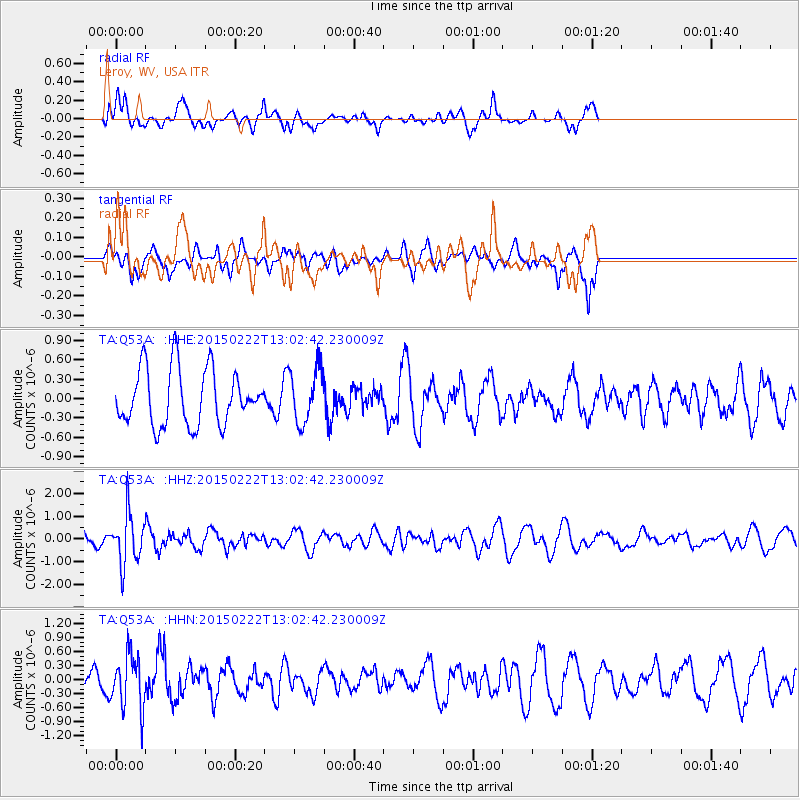
Q53A Leroy, WV, USA - Earthquake Result Viewer
*The percent match for this event was below the threshold and hence no stack was calculated.
| Earthquake location: |
Colombia |
| Earthquake latitude/longitude: |
2.7/-76.5 |
| Earthquake time(UTC): |
2015/02/22 (053) 12:56:24 GMT |
| Earthquake Depth: |
151 km |
| Earthquake Magnitude: |
5.6 MB |
| Earthquake Catalog/Contributor: |
NEIC PDE/NEIC COMCAT |
|
| Network: |
TA USArray Transportable Network (new EarthScope stations) |
| Station: |
Q53A Leroy, WV, USA |
| Lat/Lon: |
38.86 N/81.53 W |
| Elevation: |
310 m |
|
| Distance: |
36.3 deg |
| Az: |
353.36 deg |
| Baz: |
171.493 deg |
| Ray Param: |
$rayparam |
*The percent match for this event was below the threshold and hence was not used in the summary stack. |
|
| Radial Match: |
62.169437 % |
| Radial Bump: |
400 |
| Transverse Match: |
53.084064 % |
| Transverse Bump: |
359 |
| SOD ConfigId: |
7019011 |
| Insert Time: |
2019-04-17 00:37:05.157 +0000 |
| GWidth: |
2.5 |
| Max Bumps: |
400 |
| Tol: |
0.001 |
|
Signal To Noise
| Channel | StoN | STA | LTA |
| TA:Q53A: :HHZ:20150222T13:02:42.230009Z | 3.580911 | 1.1012213E-6 | 3.0752545E-7 |
| TA:Q53A: :HHN:20150222T13:02:42.230009Z | 1.3480625 | 5.7253243E-7 | 4.2470765E-7 |
| TA:Q53A: :HHE:20150222T13:02:42.230009Z | 0.98645234 | 4.2245006E-7 | 4.2825187E-7 |
| Arrivals |
| Ps | |
| PpPs | |
| PsPs/PpSs | |


