You are here: Home > Network List > TA - USArray Transportable Network (new EarthScope stations) Stations List
> Station T25A Trinidad, CO, USA > Earthquake Result Viewer
T25A Trinidad, CO, USA - Earthquake Result Viewer
*The percent match for this event was below the threshold and hence no stack was calculated.
| Earthquake location: |
Colombia |
| Earthquake latitude/longitude: |
2.7/-76.5 |
| Earthquake time(UTC): |
2015/02/22 (053) 12:56:24 GMT |
| Earthquake Depth: |
151 km |
| Earthquake Magnitude: |
5.6 MB |
| Earthquake Catalog/Contributor: |
NEIC PDE/NEIC COMCAT |
|
| Network: |
TA USArray Transportable Network (new EarthScope stations) |
| Station: |
T25A Trinidad, CO, USA |
| Lat/Lon: |
37.14 N/104.41 W |
| Elevation: |
2017 m |
|
| Distance: |
42.8 deg |
| Az: |
326.622 deg |
| Baz: |
136.549 deg |
| Ray Param: |
$rayparam |
*The percent match for this event was below the threshold and hence was not used in the summary stack. |
|
| Radial Match: |
55.57324 % |
| Radial Bump: |
400 |
| Transverse Match: |
67.9458 % |
| Transverse Bump: |
400 |
| SOD ConfigId: |
7019011 |
| Insert Time: |
2019-04-17 00:37:17.236 +0000 |
| GWidth: |
2.5 |
| Max Bumps: |
400 |
| Tol: |
0.001 |
|
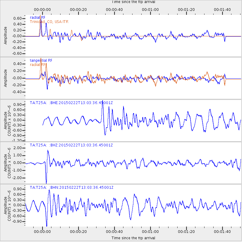
Signal To Noise
| Channel | StoN | STA | LTA |
| TA:T25A: :BHZ:20150222T13:03:36.45001Z | 9.278609 | 9.92967E-7 | 1.0701678E-7 |
| TA:T25A: :BHN:20150222T13:03:36.45001Z | 2.502357 | 5.086843E-7 | 2.0328207E-7 |
| TA:T25A: :BHE:20150222T13:03:36.45001Z | 3.2605474 | 5.0341947E-7 | 1.5439721E-7 |
| Arrivals |
| Ps | |
| PpPs | |
| PsPs/PpSs | |


