You are here: Home > Network List > II - Global Seismograph Network (GSN - IRIS/IDA) Stations List
> Station KURK Kurchatov, Kazakhstan > Earthquake Result Viewer
KURK Kurchatov, Kazakhstan - Earthquake Result Viewer
| Earthquake location: |
Southern Sumatra, Indonesia |
| Earthquake latitude/longitude: |
-2.4/104.0 |
| Earthquake time(UTC): |
2004/07/25 (207) 14:35:19 GMT |
| Earthquake Depth: |
582 km |
| Earthquake Magnitude: |
6.8 MB, 7.3 MW, 7.3 MW |
| Earthquake Catalog/Contributor: |
WHDF/NEIC |
|
| Network: |
II Global Seismograph Network (GSN - IRIS/IDA) |
| Station: |
KURK Kurchatov, Kazakhstan |
| Lat/Lon: |
50.72 N/78.62 E |
| Elevation: |
184 m |
|
| Distance: |
57.2 deg |
| Az: |
341.102 deg |
| Baz: |
149.402 deg |
| Ray Param: |
0.061209135 |
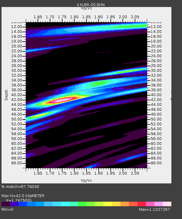
| Estimated Moho Depth: |
42.0 km |
| Estimated Crust Vp/Vs: |
1.75 |
| Assumed Crust Vp: |
6.552 km/s |
| Estimated Crust Vs: |
3.75 km/s |
| Estimated Crust Poisson's Ratio: |
0.26 |
|
| Radial Match: |
97.76048 % |
| Radial Bump: |
335 |
| Transverse Match: |
91.79914 % |
| Transverse Bump: |
400 |
| SOD ConfigId: |
2459 |
| Insert Time: |
2010-03-01 22:02:22.806 +0000 |
| GWidth: |
2.5 |
| Max Bumps: |
400 |
| Tol: |
0.001 |
|
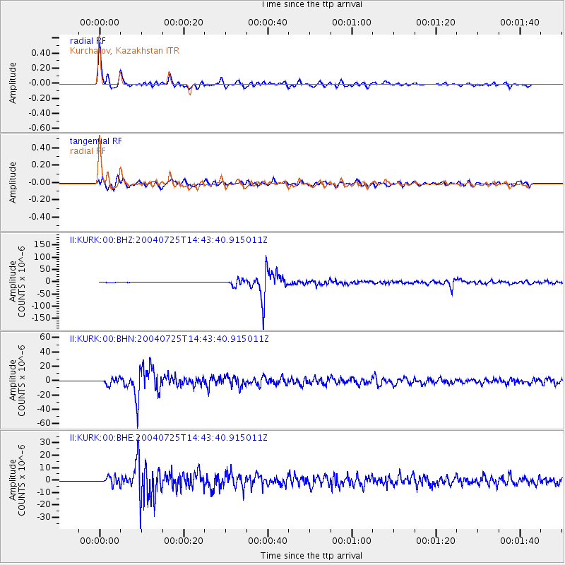
Signal To Noise
| Channel | StoN | STA | LTA |
| II:KURK:00:BHN:20040725T14:43:40.915011Z | 35.231174 | 4.3019995E-6 | 1.2210775E-7 |
| II:KURK:00:BHE:20040725T14:43:40.915011Z | 48.90464 | 2.928475E-6 | 5.988133E-8 |
| II:KURK:00:BHZ:20040725T14:43:40.915011Z | 57.746864 | 1.2042563E-5 | 2.0854056E-7 |
| Arrivals |
| Ps | 5.0 SECOND |
| PpPs | 17 SECOND |
| PsPs/PpSs | 22 SECOND |


