You are here: Home > Network List > TA - USArray Transportable Network (new EarthScope stations) Stations List
> Station V56A Mocksville, NC, USA > Earthquake Result Viewer
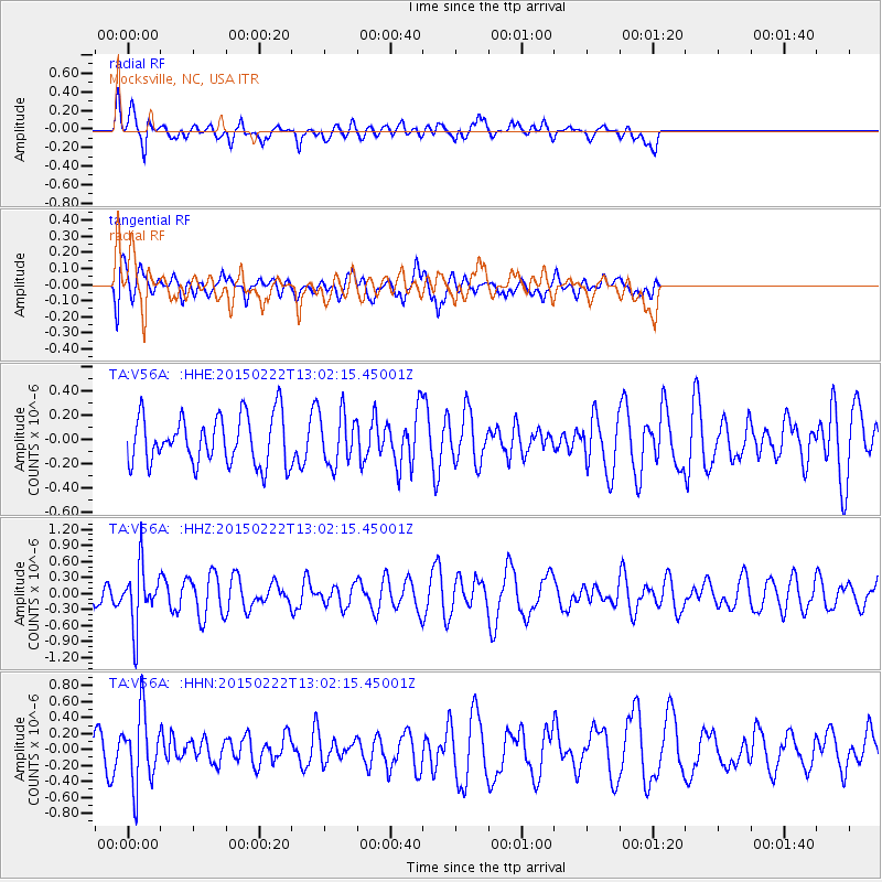
V56A Mocksville, NC, USA - Earthquake Result Viewer
*The percent match for this event was below the threshold and hence no stack was calculated.
| Earthquake location: |
Colombia |
| Earthquake latitude/longitude: |
2.7/-76.5 |
| Earthquake time(UTC): |
2015/02/22 (053) 12:56:24 GMT |
| Earthquake Depth: |
151 km |
| Earthquake Magnitude: |
5.6 MB |
| Earthquake Catalog/Contributor: |
NEIC PDE/NEIC COMCAT |
|
| Network: |
TA USArray Transportable Network (new EarthScope stations) |
| Station: |
V56A Mocksville, NC, USA |
| Lat/Lon: |
35.81 N/80.50 W |
| Elevation: |
237 m |
|
| Distance: |
33.2 deg |
| Az: |
354.05 deg |
| Baz: |
172.681 deg |
| Ray Param: |
$rayparam |
*The percent match for this event was below the threshold and hence was not used in the summary stack. |
|
| Radial Match: |
73.4722 % |
| Radial Bump: |
400 |
| Transverse Match: |
62.34574 % |
| Transverse Bump: |
400 |
| SOD ConfigId: |
7019011 |
| Insert Time: |
2019-04-17 00:37:26.497 +0000 |
| GWidth: |
2.5 |
| Max Bumps: |
400 |
| Tol: |
0.001 |
|
Signal To Noise
| Channel | StoN | STA | LTA |
| TA:V56A: :HHZ:20150222T13:02:15.45001Z | 2.5869873 | 5.598061E-7 | 2.1639306E-7 |
| TA:V56A: :HHN:20150222T13:02:15.45001Z | 3.078548 | 4.533868E-7 | 1.4727294E-7 |
| TA:V56A: :HHE:20150222T13:02:15.45001Z | 1.0334373 | 2.0500642E-7 | 1.9837336E-7 |
| Arrivals |
| Ps | |
| PpPs | |
| PsPs/PpSs | |


