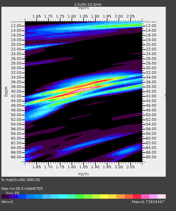
KURK Kurchatov, Kazakhstan - Earthquake Result Viewer
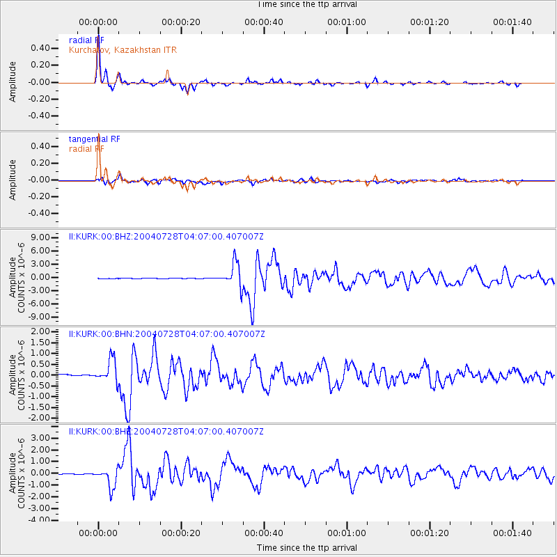
Earthquake location: Irian Jaya Region, Indonesia
Earthquake latitude/longitude: -0.4/133.1
Earthquake time(UTC): 2004/07/28 (210) 03:56:28 GMT
Earthquake Depth: 13 km
Earthquake Magnitude: 6.0 MB, 6.3 MS, 6.5 MW, 6.4 MW
Earthquake Catalog/Contributor: WHDF/NEIC
Network: II Global Seismograph Network (GSN - IRIS/IDA)
Station: KURK Kurchatov, Kazakhstan
Lat/Lon: 50.72 N/78.62 E
Elevation: 184 m
Distance: 68.7 deg
Az: 326.265 deg
Baz: 119.126 deg
Ray Param: 0.056135047
Estimated Moho Depth: 39.0 km
Estimated Crust Vp/Vs: 1.85
Assumed Crust Vp: 6.552 km/s
Estimated Crust Vs: 3.542 km/s
Estimated Crust Poisson's Ratio: 0.29
Radial Match: 98.399185 %
Radial Bump: 228
Transverse Match: 87.11712 %
Transverse Bump: 400
SOD ConfigId: 2459
Insert Time: 2010-03-01 22:02:24.325 +0000
GWidth: 2.5
Max Bumps: 400
Tol: 0.001

Signal To Noise

ChannelStoNSTALTA
II:KURK:00:BHN:20040728T04:07:00.407007Z6.5570085.8020464E-78.8486196E-8
II:KURK:00:BHE:20040728T04:07:00.407007Z29.4334188.5953144E-72.920257E-8
II:KURK:00:BHZ:20040728T04:07:00.407007Z52.5617522.8437858E-65.410371E-8
Arrivals
Ps5.3 SECOND
PpPs16 SECOND
PsPs/PpSs22 SECOND