You are here: Home > Network List > NM - Cooperative New Madrid Seismic Network Stations List
> Station MGMO Mountain Grove, MO > Earthquake Result Viewer
MGMO Mountain Grove, MO - Earthquake Result Viewer
| Earthquake location: |
Southern Alaska |
| Earthquake latitude/longitude: |
60.0/-152.2 |
| Earthquake time(UTC): |
2014/05/10 (130) 14:16:08 GMT |
| Earthquake Depth: |
96 km |
| Earthquake Magnitude: |
5.8 ML, 5.5 MI, 5.7 MWP |
| Earthquake Catalog/Contributor: |
NEIC PDE/NEIC COMCAT |
|
| Network: |
NM Cooperative New Madrid Seismic Network |
| Station: |
MGMO Mountain Grove, MO |
| Lat/Lon: |
37.15 N/92.27 W |
| Elevation: |
453 m |
|
| Distance: |
43.8 deg |
| Az: |
93.673 deg |
| Baz: |
321.131 deg |
| Ray Param: |
0.071969844 |
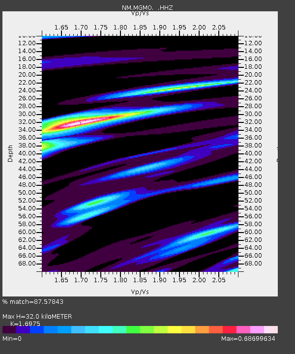
| Estimated Moho Depth: |
32.0 km |
| Estimated Crust Vp/Vs: |
1.70 |
| Assumed Crust Vp: |
6.53 km/s |
| Estimated Crust Vs: |
3.847 km/s |
| Estimated Crust Poisson's Ratio: |
0.23 |
|
| Radial Match: |
87.57843 % |
| Radial Bump: |
224 |
| Transverse Match: |
60.375584 % |
| Transverse Bump: |
329 |
| SOD ConfigId: |
626651 |
| Insert Time: |
2014-05-24 14:48:34.342 +0000 |
| GWidth: |
2.5 |
| Max Bumps: |
400 |
| Tol: |
0.001 |
|

Signal To Noise
| Channel | StoN | STA | LTA |
| NM:MGMO: :HHZ:20140510T14:23:34.097992Z | 21.30962 | 9.917279E-7 | 4.6538975E-8 |
| NM:MGMO: :HHN:20140510T14:23:34.097992Z | 16.428759 | 5.7842124E-7 | 3.5207847E-8 |
| NM:MGMO: :HHE:20140510T14:23:34.097992Z | 6.619537 | 3.3328445E-7 | 5.0348604E-8 |
| Arrivals |
| Ps | 3.7 SECOND |
| PpPs | 12 SECOND |
| PsPs/PpSs | 16 SECOND |


