You are here: Home > Network List > TA - USArray Transportable Network (new EarthScope stations) Stations List
> Station X43A Marvell, AR, USA > Earthquake Result Viewer
X43A Marvell, AR, USA - Earthquake Result Viewer
*The percent match for this event was below the threshold and hence no stack was calculated.
| Earthquake location: |
Colombia |
| Earthquake latitude/longitude: |
2.7/-76.5 |
| Earthquake time(UTC): |
2015/02/22 (053) 12:56:24 GMT |
| Earthquake Depth: |
151 km |
| Earthquake Magnitude: |
5.6 MB |
| Earthquake Catalog/Contributor: |
NEIC PDE/NEIC COMCAT |
|
| Network: |
TA USArray Transportable Network (new EarthScope stations) |
| Station: |
X43A Marvell, AR, USA |
| Lat/Lon: |
34.52 N/90.88 W |
| Elevation: |
53 m |
|
| Distance: |
34.4 deg |
| Az: |
338.71 deg |
| Baz: |
153.943 deg |
| Ray Param: |
$rayparam |
*The percent match for this event was below the threshold and hence was not used in the summary stack. |
|
| Radial Match: |
71.05094 % |
| Radial Bump: |
400 |
| Transverse Match: |
65.375946 % |
| Transverse Bump: |
398 |
| SOD ConfigId: |
7019011 |
| Insert Time: |
2019-04-17 00:37:36.302 +0000 |
| GWidth: |
2.5 |
| Max Bumps: |
400 |
| Tol: |
0.001 |
|
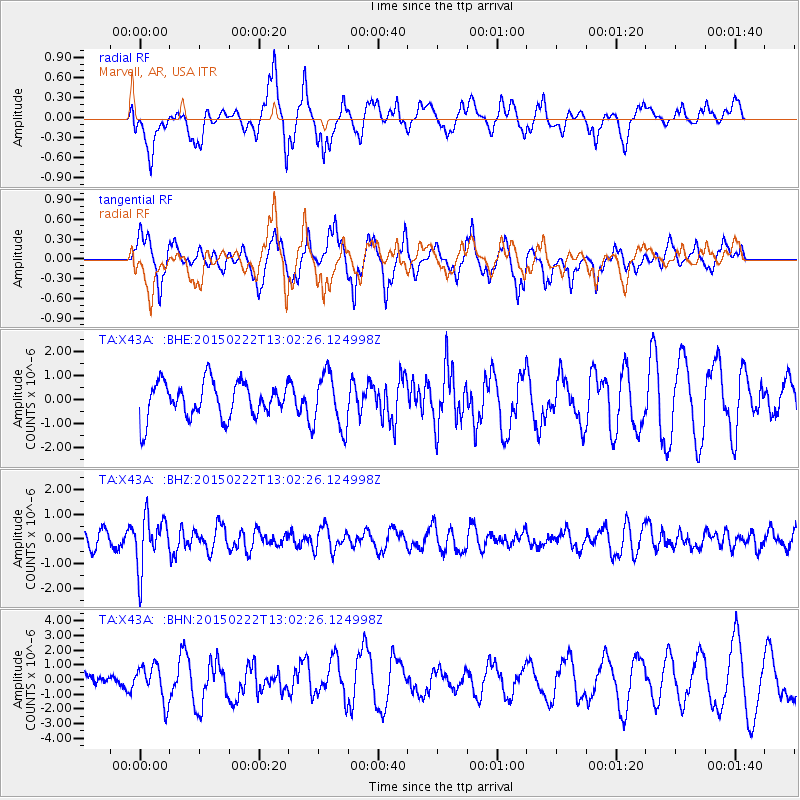
Signal To Noise
| Channel | StoN | STA | LTA |
| TA:X43A: :BHZ:20150222T13:02:26.124998Z | 2.3759017 | 1.0498804E-6 | 4.4188715E-7 |
| TA:X43A: :BHN:20150222T13:02:26.124998Z | 2.927081 | 1.2334863E-6 | 4.2140488E-7 |
| TA:X43A: :BHE:20150222T13:02:26.124998Z | 1.7215023 | 1.1175606E-6 | 6.491775E-7 |
| Arrivals |
| Ps | |
| PpPs | |
| PsPs/PpSs | |


