You are here: Home > Network List > TA - USArray Transportable Network (new EarthScope stations) Stations List
> Station 833A Chaparral WMA, Artesia Wells, TX, USA > Earthquake Result Viewer
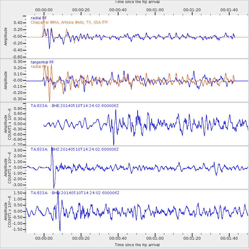
833A Chaparral WMA, Artesia Wells, TX, USA - Earthquake Result Viewer
*The percent match for this event was below the threshold and hence no stack was calculated.
| Earthquake location: |
Southern Alaska |
| Earthquake latitude/longitude: |
60.0/-152.2 |
| Earthquake time(UTC): |
2014/05/10 (130) 14:16:08 GMT |
| Earthquake Depth: |
96 km |
| Earthquake Magnitude: |
5.8 ML, 5.5 MI, 5.7 MWP |
| Earthquake Catalog/Contributor: |
NEIC PDE/NEIC COMCAT |
|
| Network: |
TA USArray Transportable Network (new EarthScope stations) |
| Station: |
833A Chaparral WMA, Artesia Wells, TX, USA |
| Lat/Lon: |
28.32 N/99.39 W |
| Elevation: |
171 m |
|
| Distance: |
47.5 deg |
| Az: |
107.703 deg |
| Baz: |
327.119 deg |
| Ray Param: |
$rayparam |
*The percent match for this event was below the threshold and hence was not used in the summary stack. |
|
| Radial Match: |
65.62158 % |
| Radial Bump: |
400 |
| Transverse Match: |
61.091343 % |
| Transverse Bump: |
347 |
| SOD ConfigId: |
626651 |
| Insert Time: |
2014-05-24 14:54:45.298 +0000 |
| GWidth: |
2.5 |
| Max Bumps: |
400 |
| Tol: |
0.001 |
|
Signal To Noise
| Channel | StoN | STA | LTA |
| TA:833A: :BHZ:20140510T14:24:02.600006Z | 6.531311 | 1.0900495E-6 | 1.6689597E-7 |
| TA:833A: :BHN:20140510T14:24:02.600006Z | 1.7620335 | 2.9820944E-7 | 1.6924166E-7 |
| TA:833A: :BHE:20140510T14:24:02.600006Z | 1.4410298 | 2.1507407E-7 | 1.4925027E-7 |
| Arrivals |
| Ps | |
| PpPs | |
| PsPs/PpSs | |


