You are here: Home > Network List > UW - Pacific Northwest Regional Seismic Network Stations List
> Station MRBL Marblemount, WA, USA > Earthquake Result Viewer
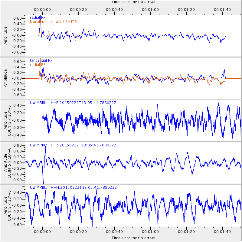
MRBL Marblemount, WA, USA - Earthquake Result Viewer
*The percent match for this event was below the threshold and hence no stack was calculated.
| Earthquake location: |
Colombia |
| Earthquake latitude/longitude: |
2.7/-76.5 |
| Earthquake time(UTC): |
2015/02/22 (053) 12:56:24 GMT |
| Earthquake Depth: |
151 km |
| Earthquake Magnitude: |
5.6 MB |
| Earthquake Catalog/Contributor: |
NEIC PDE/NEIC COMCAT |
|
| Network: |
UW Pacific Northwest Regional Seismic Network |
| Station: |
MRBL Marblemount, WA, USA |
| Lat/Lon: |
48.52 N/121.48 W |
| Elevation: |
75 m |
|
| Distance: |
59.7 deg |
| Az: |
327.021 deg |
| Baz: |
125.133 deg |
| Ray Param: |
$rayparam |
*The percent match for this event was below the threshold and hence was not used in the summary stack. |
|
| Radial Match: |
59.194675 % |
| Radial Bump: |
400 |
| Transverse Match: |
45.539467 % |
| Transverse Bump: |
400 |
| SOD ConfigId: |
7019011 |
| Insert Time: |
2019-04-17 00:39:18.858 +0000 |
| GWidth: |
2.5 |
| Max Bumps: |
400 |
| Tol: |
0.001 |
|
Signal To Noise
| Channel | StoN | STA | LTA |
| UW:MRBL: :HHZ:20150222T13:05:41.788022Z | 4.3427625 | 4.2384957E-7 | 9.759907E-8 |
| UW:MRBL: :HHN:20150222T13:05:41.788022Z | 0.9005168 | 2.2833602E-7 | 2.5356107E-7 |
| UW:MRBL: :HHE:20150222T13:05:41.788022Z | 0.97595304 | 1.3687817E-7 | 1.4025078E-7 |
| Arrivals |
| Ps | |
| PpPs | |
| PsPs/PpSs | |


