You are here: Home > Network List > TA - USArray Transportable Network (new EarthScope stations) Stations List
> Station E58A La Victoria, QC, CAN > Earthquake Result Viewer
E58A La Victoria, QC, CAN - Earthquake Result Viewer
| Earthquake location: |
Southern Alaska |
| Earthquake latitude/longitude: |
60.0/-152.2 |
| Earthquake time(UTC): |
2014/05/10 (130) 14:16:08 GMT |
| Earthquake Depth: |
96 km |
| Earthquake Magnitude: |
5.8 ML, 5.5 MI, 5.7 MWP |
| Earthquake Catalog/Contributor: |
NEIC PDE/NEIC COMCAT |
|
| Network: |
TA USArray Transportable Network (new EarthScope stations) |
| Station: |
E58A La Victoria, QC, CAN |
| Lat/Lon: |
46.37 N/73.28 W |
| Elevation: |
233 m |
|
| Distance: |
46.3 deg |
| Az: |
70.014 deg |
| Baz: |
317.007 deg |
| Ray Param: |
0.07041669 |
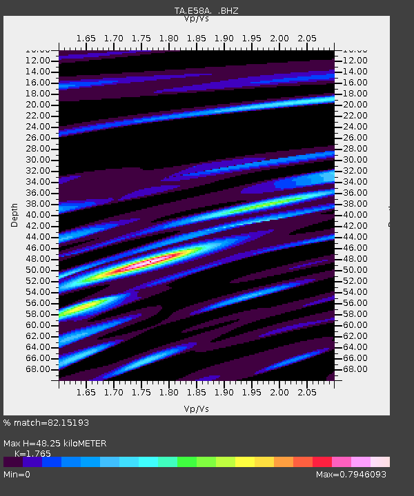
| Estimated Moho Depth: |
48.25 km |
| Estimated Crust Vp/Vs: |
1.76 |
| Assumed Crust Vp: |
6.61 km/s |
| Estimated Crust Vs: |
3.745 km/s |
| Estimated Crust Poisson's Ratio: |
0.26 |
|
| Radial Match: |
82.15193 % |
| Radial Bump: |
400 |
| Transverse Match: |
56.78726 % |
| Transverse Bump: |
400 |
| SOD ConfigId: |
626651 |
| Insert Time: |
2014-05-24 14:56:45.554 +0000 |
| GWidth: |
2.5 |
| Max Bumps: |
400 |
| Tol: |
0.001 |
|
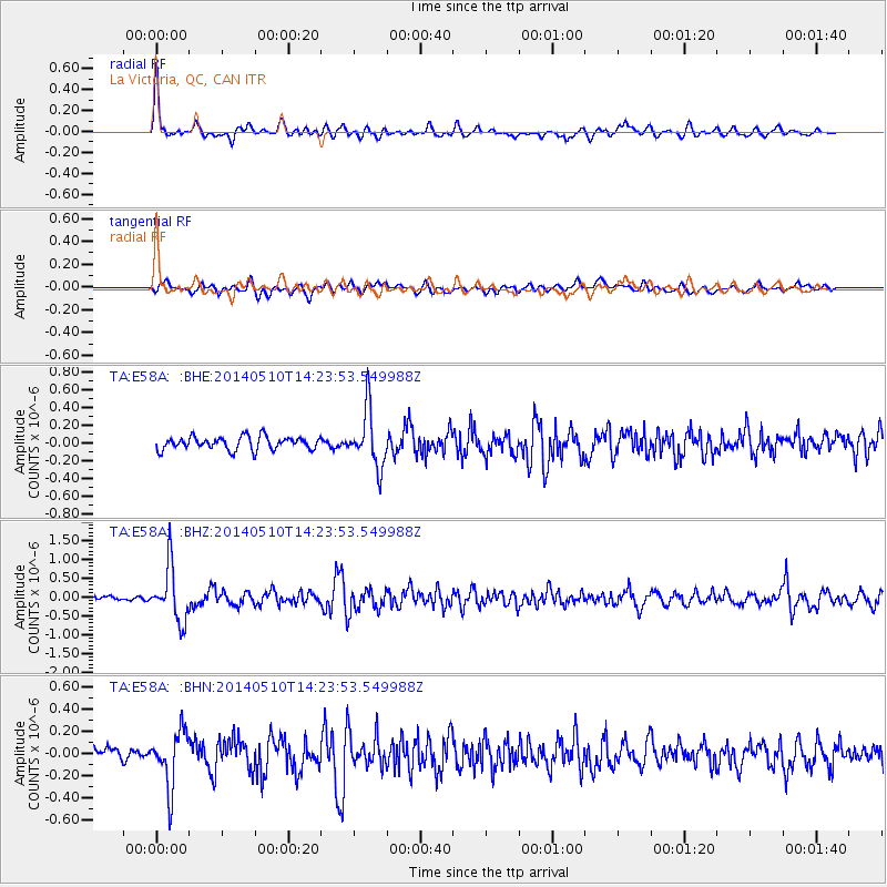
Signal To Noise
| Channel | StoN | STA | LTA |
| TA:E58A: :BHZ:20140510T14:23:53.549988Z | 9.481608 | 7.21278E-7 | 7.6071274E-8 |
| TA:E58A: :BHN:20140510T14:23:53.549988Z | 2.60145 | 2.5564105E-7 | 9.826868E-8 |
| TA:E58A: :BHE:20140510T14:23:53.549988Z | 4.3642244 | 3.212491E-7 | 7.360966E-8 |
| Arrivals |
| Ps | 6.0 SECOND |
| PpPs | 19 SECOND |
| PsPs/PpSs | 25 SECOND |


