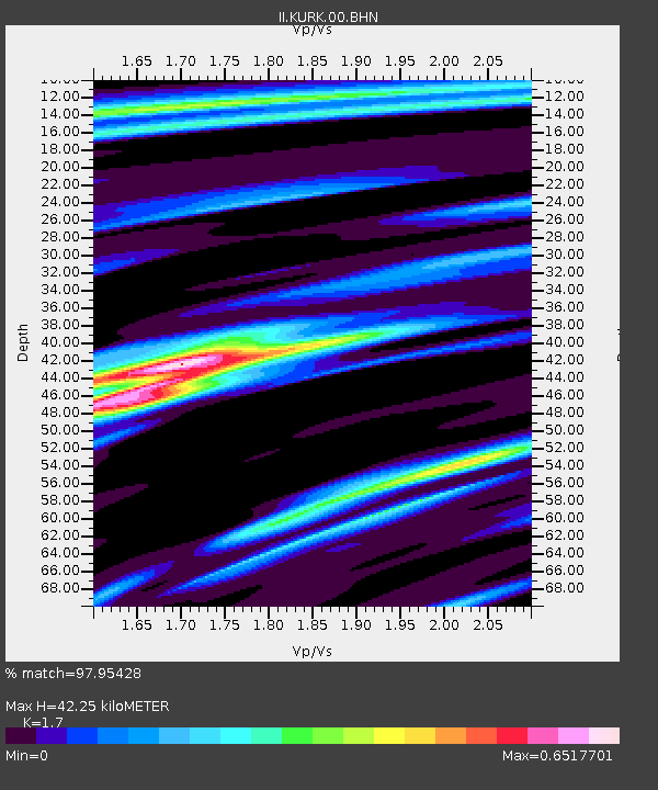
KURK Kurchatov, Kazakhstan - Earthquake Result Viewer
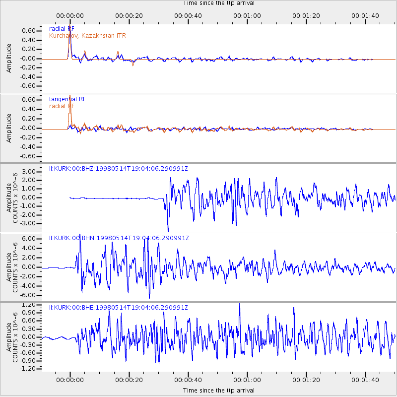
Earthquake location: Off East Coast Of Honshu, Japan
Earthquake latitude/longitude: 40.3/143.3
Earthquake time(UTC): 1998/05/14 (134) 18:56:23 GMT
Earthquake Depth: 33 km
Earthquake Magnitude: 5.8 MB, 5.7 MS, 5.9 UNKNOWN
Earthquake Catalog/Contributor: WHDF/NEIC
Network: II Global Seismograph Network (GSN - IRIS/IDA)
Station: KURK Kurchatov, Kazakhstan
Lat/Lon: 50.72 N/78.62 E
Elevation: 184 m
Distance: 45.1 deg
Az: 305.877 deg
Baz: 77.281 deg
Ray Param: 0.071401834
Estimated Moho Depth: 42.25 km
Estimated Crust Vp/Vs: 1.70
Assumed Crust Vp: 6.552 km/s
Estimated Crust Vs: 3.854 km/s
Estimated Crust Poisson's Ratio: 0.24
Radial Match: 97.95428 %
Radial Bump: 355
Transverse Match: 84.07714 %
Transverse Bump: 400
SOD ConfigId: 4480
Insert Time: 2010-03-01 22:03:25.779 +0000
GWidth: 2.5
Max Bumps: 400
Tol: 0.001

Signal To Noise

ChannelStoNSTALTA
II:KURK:00:BHN:19980514T19:04:06.290991Z35.4527242.4967464E-67.0424676E-8
II:KURK:00:BHE:19980514T19:04:06.290991Z3.69083051.7693871E-74.794008E-8
II:KURK:00:BHZ:19980514T19:04:06.290991Z39.9666861.2862489E-63.2183028E-8
Arrivals
Ps4.8 SECOND
PpPs16 SECOND
PsPs/PpSs21 SECOND