You are here: Home > Network List > TA - USArray Transportable Network (new EarthScope stations) Stations List
> Station L59A Walton, NY, USA > Earthquake Result Viewer
L59A Walton, NY, USA - Earthquake Result Viewer
| Earthquake location: |
Southern Alaska |
| Earthquake latitude/longitude: |
60.0/-152.2 |
| Earthquake time(UTC): |
2014/05/10 (130) 14:16:08 GMT |
| Earthquake Depth: |
96 km |
| Earthquake Magnitude: |
5.8 ML, 5.5 MI, 5.7 MWP |
| Earthquake Catalog/Contributor: |
NEIC PDE/NEIC COMCAT |
|
| Network: |
TA USArray Transportable Network (new EarthScope stations) |
| Station: |
L59A Walton, NY, USA |
| Lat/Lon: |
42.19 N/75.04 W |
| Elevation: |
677 m |
|
| Distance: |
48.6 deg |
| Az: |
75.087 deg |
| Baz: |
319.211 deg |
| Ray Param: |
0.06895313 |
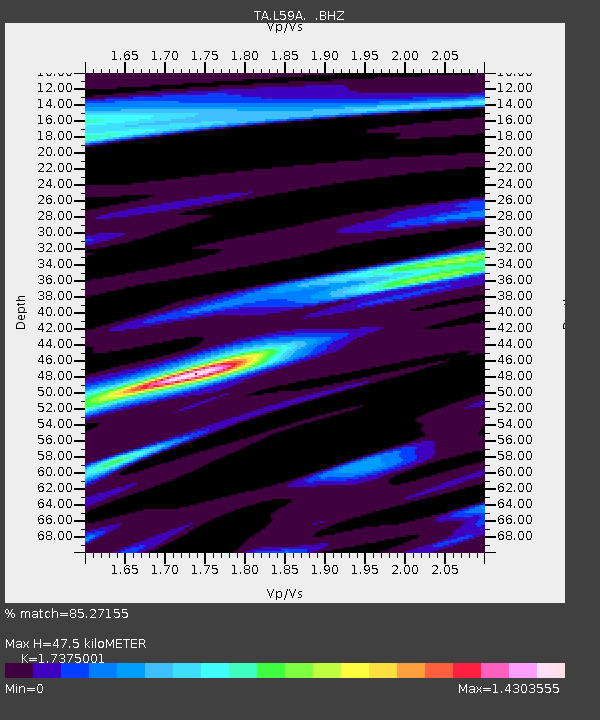
| Estimated Moho Depth: |
47.5 km |
| Estimated Crust Vp/Vs: |
1.74 |
| Assumed Crust Vp: |
6.419 km/s |
| Estimated Crust Vs: |
3.695 km/s |
| Estimated Crust Poisson's Ratio: |
0.25 |
|
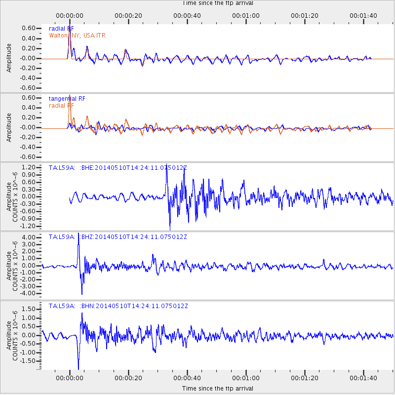
| Radial Match: |
85.27155 % |
| Radial Bump: |
400 |
| Transverse Match: |
61.259342 % |
| Transverse Bump: |
400 |
| SOD ConfigId: |
626651 |
| Insert Time: |
2014-05-24 15:04:34.934 +0000 |
| GWidth: |
2.5 |
| Max Bumps: |
400 |
| Tol: |
0.001 |
|
Signal To Noise
| Channel | StoN | STA | LTA |
| TA:L59A: :BHZ:20140510T14:24:11.075012Z | 10.957789 | 1.5362798E-6 | 1.4019979E-7 |
| TA:L59A: :BHN:20140510T14:24:11.075012Z | 5.810808 | 6.2179544E-7 | 1.07006706E-7 |
| TA:L59A: :BHE:20140510T14:24:11.075012Z | 4.156477 | 4.3362286E-7 | 1.0432461E-7 |
| Arrivals |
| Ps | 5.8 SECOND |
| PpPs | 19 SECOND |
| PsPs/PpSs | 25 SECOND |


