You are here: Home > Network List > TA - USArray Transportable Network (new EarthScope stations) Stations List
> Station M63A Gales Ferry, CT, USA > Earthquake Result Viewer
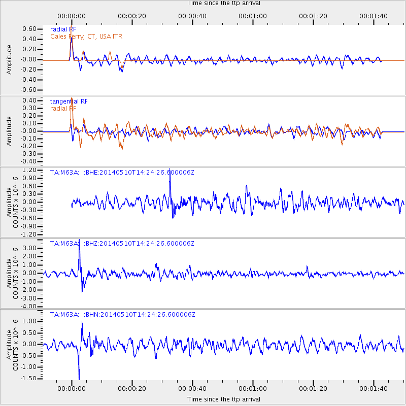
M63A Gales Ferry, CT, USA - Earthquake Result Viewer
*The percent match for this event was below the threshold and hence no stack was calculated.
| Earthquake location: |
Southern Alaska |
| Earthquake latitude/longitude: |
60.0/-152.2 |
| Earthquake time(UTC): |
2014/05/10 (130) 14:16:08 GMT |
| Earthquake Depth: |
96 km |
| Earthquake Magnitude: |
5.8 ML, 5.5 MI, 5.7 MWP |
| Earthquake Catalog/Contributor: |
NEIC PDE/NEIC COMCAT |
|
| Network: |
TA USArray Transportable Network (new EarthScope stations) |
| Station: |
M63A Gales Ferry, CT, USA |
| Lat/Lon: |
41.40 N/72.05 W |
| Elevation: |
44 m |
|
| Distance: |
50.6 deg |
| Az: |
73.511 deg |
| Baz: |
320.179 deg |
| Ray Param: |
$rayparam |
*The percent match for this event was below the threshold and hence was not used in the summary stack. |
|
| Radial Match: |
73.23094 % |
| Radial Bump: |
400 |
| Transverse Match: |
56.16125 % |
| Transverse Bump: |
400 |
| SOD ConfigId: |
626651 |
| Insert Time: |
2014-05-24 15:06:09.515 +0000 |
| GWidth: |
2.5 |
| Max Bumps: |
400 |
| Tol: |
0.001 |
|
Signal To Noise
| Channel | StoN | STA | LTA |
| TA:M63A: :BHZ:20140510T14:24:26.600006Z | 5.5170717 | 1.140241E-6 | 2.0667504E-7 |
| TA:M63A: :BHN:20140510T14:24:26.600006Z | 3.7245512 | 4.2974887E-7 | 1.15382726E-7 |
| TA:M63A: :BHE:20140510T14:24:26.600006Z | 2.5273383 | 3.5209146E-7 | 1.3931314E-7 |
| Arrivals |
| Ps | |
| PpPs | |
| PsPs/PpSs | |


