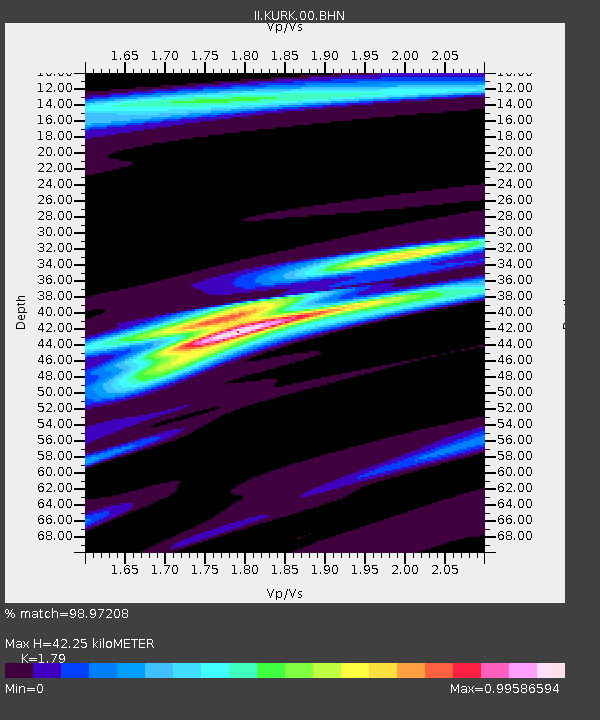
KURK Kurchatov, Kazakhstan - Earthquake Result Viewer
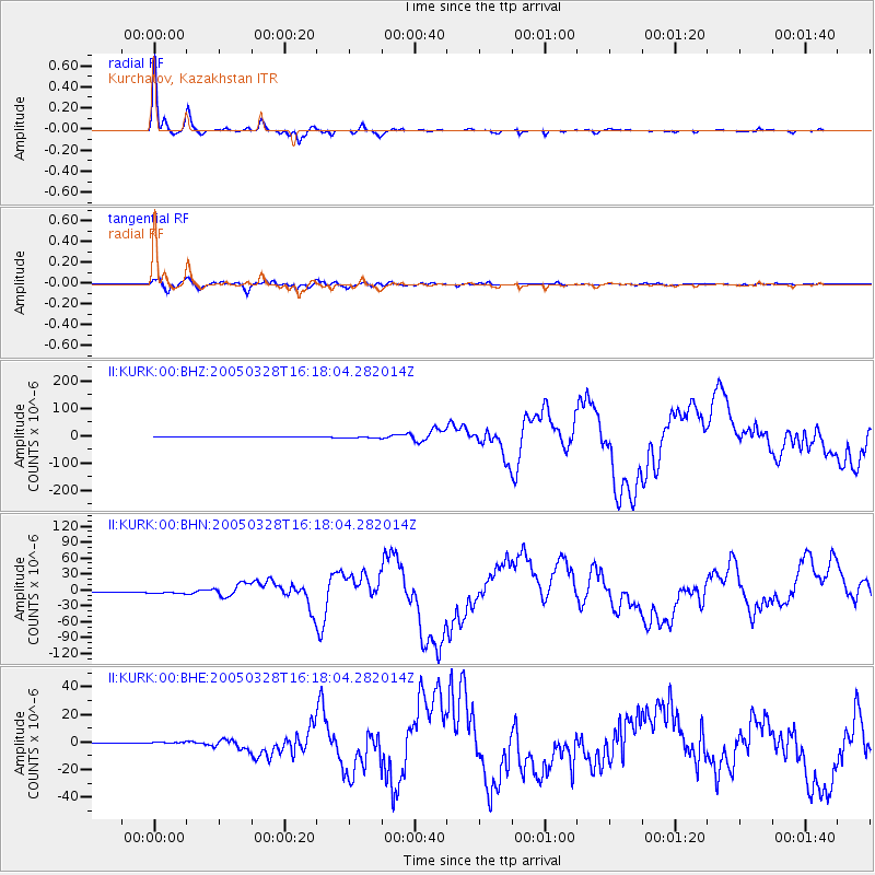
Earthquake location: Northern Sumatra, Indonesia
Earthquake latitude/longitude: 2.1/97.1
Earthquake time(UTC): 2005/03/28 (087) 16:09:36 GMT
Earthquake Depth: 30 km
Earthquake Magnitude: 7.2 MB, 8.4 MS, 8.7 MW, 8.1 MW
Earthquake Catalog/Contributor: WHDF/NEIC
Network: II Global Seismograph Network (GSN - IRIS/IDA)
Station: KURK Kurchatov, Kazakhstan
Lat/Lon: 50.72 N/78.62 E
Elevation: 184 m
Distance: 50.9 deg
Az: 344.948 deg
Baz: 155.906 deg
Ray Param: 0.06768623
Estimated Moho Depth: 42.25 km
Estimated Crust Vp/Vs: 1.79
Assumed Crust Vp: 6.552 km/s
Estimated Crust Vs: 3.661 km/s
Estimated Crust Poisson's Ratio: 0.27
Radial Match: 98.97208 %
Radial Bump: 216
Transverse Match: 95.12313 %
Transverse Bump: 400
SOD ConfigId: 2459
Insert Time: 2010-03-01 22:03:45.901 +0000
GWidth: 2.5
Max Bumps: 400
Tol: 0.001

Signal To Noise

ChannelStoNSTALTA
II:KURK:00:BHN:20050328T16:18:04.282014Z6.35726932.345379E-63.689287E-7
II:KURK:00:BHE:20050328T16:18:04.282014Z3.2156461.0312231E-63.2068922E-7
II:KURK:00:BHZ:20050328T16:18:04.282014Z6.2870663.6441136E-65.796207E-7
Arrivals
Ps5.4 SECOND
PpPs17 SECOND
PsPs/PpSs22 SECOND