You are here: Home > Network List > TA - USArray Transportable Network (new EarthScope stations) Stations List
> Station O55A Ligonier, PA, USA > Earthquake Result Viewer
O55A Ligonier, PA, USA - Earthquake Result Viewer
| Earthquake location: |
Southern Alaska |
| Earthquake latitude/longitude: |
60.0/-152.2 |
| Earthquake time(UTC): |
2014/05/10 (130) 14:16:08 GMT |
| Earthquake Depth: |
96 km |
| Earthquake Magnitude: |
5.8 ML, 5.5 MI, 5.7 MWP |
| Earthquake Catalog/Contributor: |
NEIC PDE/NEIC COMCAT |
|
| Network: |
TA USArray Transportable Network (new EarthScope stations) |
| Station: |
O55A Ligonier, PA, USA |
| Lat/Lon: |
40.21 N/79.30 W |
| Elevation: |
469 m |
|
| Distance: |
48.0 deg |
| Az: |
80.086 deg |
| Baz: |
319.742 deg |
| Ray Param: |
0.06934189 |
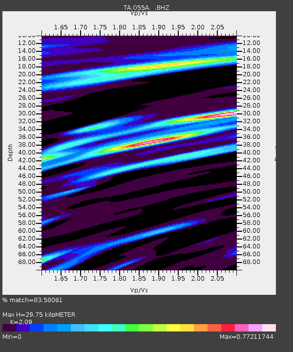
| Estimated Moho Depth: |
29.75 km |
| Estimated Crust Vp/Vs: |
2.09 |
| Assumed Crust Vp: |
6.121 km/s |
| Estimated Crust Vs: |
2.928 km/s |
| Estimated Crust Poisson's Ratio: |
0.35 |
|
| Radial Match: |
83.58061 % |
| Radial Bump: |
400 |
| Transverse Match: |
60.02598 % |
| Transverse Bump: |
400 |
| SOD ConfigId: |
626651 |
| Insert Time: |
2014-05-24 15:08:21.317 +0000 |
| GWidth: |
2.5 |
| Max Bumps: |
400 |
| Tol: |
0.001 |
|
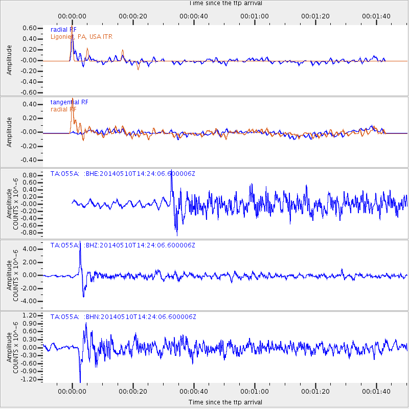
Signal To Noise
| Channel | StoN | STA | LTA |
| TA:O55A: :BHZ:20140510T14:24:06.600006Z | 21.624956 | 1.5550473E-6 | 7.190985E-8 |
| TA:O55A: :BHN:20140510T14:24:06.600006Z | 4.831674 | 4.1672158E-7 | 8.6247866E-8 |
| TA:O55A: :BHE:20140510T14:24:06.600006Z | 5.5869765 | 3.4712784E-7 | 6.2131605E-8 |
| Arrivals |
| Ps | 5.5 SECOND |
| PpPs | 14 SECOND |
| PsPs/PpSs | 20 SECOND |


