You are here: Home > Network List > TA - USArray Transportable Network (new EarthScope stations) Stations List
> Station O60A Telford, PA, USA > Earthquake Result Viewer
O60A Telford, PA, USA - Earthquake Result Viewer

| Earthquake location: |
Southern Alaska |
| Earthquake latitude/longitude: |
60.0/-152.2 |
| Earthquake time(UTC): |
2014/05/10 (130) 14:16:08 GMT |
| Earthquake Depth: |
96 km |
| Earthquake Magnitude: |
5.8 ML, 5.5 MI, 5.7 MWP |
| Earthquake Catalog/Contributor: |
NEIC PDE/NEIC COMCAT |
|
| Network: |
TA USArray Transportable Network (new EarthScope stations) |
| Station: |
O60A Telford, PA, USA |
| Lat/Lon: |
40.32 N/75.40 W |
| Elevation: |
70 m |
|
| Distance: |
49.8 deg |
| Az: |
76.961 deg |
| Baz: |
320.198 deg |
| Ray Param: |
0.06815525 |
| Estimated Moho Depth: |
37.25 km |
| Estimated Crust Vp/Vs: |
1.79 |
| Assumed Crust Vp: |
6.283 km/s |
| Estimated Crust Vs: |
3.52 km/s |
| Estimated Crust Poisson's Ratio: |
0.27 |
|
| Radial Match: |
90.48752 % |
| Radial Bump: |
387 |
| Transverse Match: |
74.75737 % |
| Transverse Bump: |
400 |
| SOD ConfigId: |
626651 |
| Insert Time: |
2014-05-24 15:08:38.365 +0000 |
| GWidth: |
2.5 |
| Max Bumps: |
400 |
| Tol: |
0.001 |
|
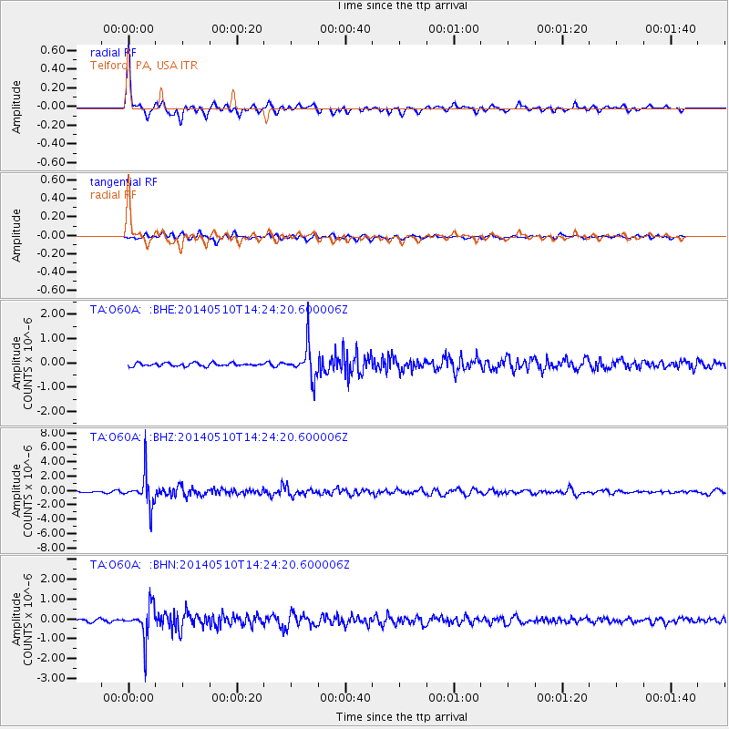
Signal To Noise
| Channel | StoN | STA | LTA |
| TA:O60A: :BHZ:20140510T14:24:20.600006Z | 23.030758 | 2.1920348E-6 | 9.5178585E-8 |
| TA:O60A: :BHN:20140510T14:24:20.600006Z | 11.316729 | 8.1249703E-7 | 7.17961E-8 |
| TA:O60A: :BHE:20140510T14:24:20.600006Z | 9.911992 | 6.589042E-7 | 6.647545E-8 |
| Arrivals |
| Ps | 4.9 SECOND |
| PpPs | 16 SECOND |
| PsPs/PpSs | 21 SECOND |


