You are here: Home > Network List > TA - USArray Transportable Network (new EarthScope stations) Stations List
> Station Q53A Leroy, WV, USA > Earthquake Result Viewer
Q53A Leroy, WV, USA - Earthquake Result Viewer
| Earthquake location: |
Southern Alaska |
| Earthquake latitude/longitude: |
60.0/-152.2 |
| Earthquake time(UTC): |
2014/05/10 (130) 14:16:08 GMT |
| Earthquake Depth: |
96 km |
| Earthquake Magnitude: |
5.8 ML, 5.5 MI, 5.7 MWP |
| Earthquake Catalog/Contributor: |
NEIC PDE/NEIC COMCAT |
|
| Network: |
TA USArray Transportable Network (new EarthScope stations) |
| Station: |
Q53A Leroy, WV, USA |
| Lat/Lon: |
38.86 N/81.53 W |
| Elevation: |
310 m |
|
| Distance: |
47.9 deg |
| Az: |
83.025 deg |
| Baz: |
320.302 deg |
| Ray Param: |
0.06938875 |
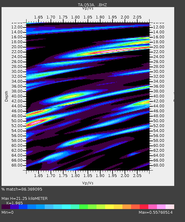
| Estimated Moho Depth: |
21.25 km |
| Estimated Crust Vp/Vs: |
1.97 |
| Assumed Crust Vp: |
6.207 km/s |
| Estimated Crust Vs: |
3.159 km/s |
| Estimated Crust Poisson's Ratio: |
0.33 |
|
| Radial Match: |
86.369095 % |
| Radial Bump: |
400 |
| Transverse Match: |
67.91617 % |
| Transverse Bump: |
400 |
| SOD ConfigId: |
626651 |
| Insert Time: |
2014-05-24 15:09:48.019 +0000 |
| GWidth: |
2.5 |
| Max Bumps: |
400 |
| Tol: |
0.001 |
|

Signal To Noise
| Channel | StoN | STA | LTA |
| TA:Q53A: :BHZ:20140510T14:24:06.049988Z | 15.604923 | 1.6447581E-6 | 1.0539995E-7 |
| TA:Q53A: :BHN:20140510T14:24:06.049988Z | 11.438396 | 6.575746E-7 | 5.7488354E-8 |
| TA:Q53A: :BHE:20140510T14:24:06.049988Z | 9.361793 | 5.4998884E-7 | 5.874824E-8 |
| Arrivals |
| Ps | 3.5 SECOND |
| PpPs | 9.7 SECOND |
| PsPs/PpSs | 13 SECOND |


