You are here: Home > Network List > TA - USArray Transportable Network (new EarthScope stations) Stations List
> Station Q58A Fox Den Farm, The Plains, VA, USA > Earthquake Result Viewer
Q58A Fox Den Farm, The Plains, VA, USA - Earthquake Result Viewer
| Earthquake location: |
Southern Alaska |
| Earthquake latitude/longitude: |
60.0/-152.2 |
| Earthquake time(UTC): |
2014/05/10 (130) 14:16:08 GMT |
| Earthquake Depth: |
96 km |
| Earthquake Magnitude: |
5.8 ML, 5.5 MI, 5.7 MWP |
| Earthquake Catalog/Contributor: |
NEIC PDE/NEIC COMCAT |
|
| Network: |
TA USArray Transportable Network (new EarthScope stations) |
| Station: |
Q58A Fox Den Farm, The Plains, VA, USA |
| Lat/Lon: |
38.94 N/77.68 W |
| Elevation: |
182 m |
|
| Distance: |
49.8 deg |
| Az: |
79.883 deg |
| Baz: |
320.638 deg |
| Ray Param: |
0.06819544 |
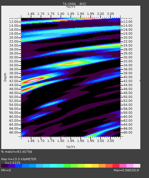
| Estimated Moho Depth: |
10.0 km |
| Estimated Crust Vp/Vs: |
2.02 |
| Assumed Crust Vp: |
6.419 km/s |
| Estimated Crust Vs: |
3.174 km/s |
| Estimated Crust Poisson's Ratio: |
0.34 |
|
| Radial Match: |
93.40756 % |
| Radial Bump: |
312 |
| Transverse Match: |
75.940575 % |
| Transverse Bump: |
400 |
| SOD ConfigId: |
626651 |
| Insert Time: |
2014-05-24 15:10:09.347 +0000 |
| GWidth: |
2.5 |
| Max Bumps: |
400 |
| Tol: |
0.001 |
|

Signal To Noise
| Channel | StoN | STA | LTA |
| TA:Q58A: :BHZ:20140510T14:24:20.123993Z | 19.52038 | 1.546196E-6 | 7.920932E-8 |
| TA:Q58A: :BHN:20140510T14:24:20.123993Z | 10.465124 | 6.8054993E-7 | 6.503028E-8 |
| TA:Q58A: :BHE:20140510T14:24:20.123993Z | 13.076632 | 5.1328794E-7 | 3.9252303E-8 |
| Arrivals |
| Ps | 1.7 SECOND |
| PpPs | 4.5 SECOND |
| PsPs/PpSs | 6.2 SECOND |


