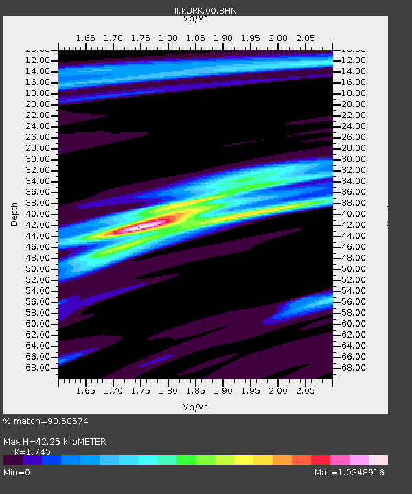
KURK Kurchatov, Kazakhstan - Earthquake Result Viewer

Earthquake location: Northern Sumatra, Indonesia
Earthquake latitude/longitude: 1.8/97.1
Earthquake time(UTC): 2005/07/05 (186) 01:52:02 GMT
Earthquake Depth: 21 km
Earthquake Magnitude: 6.2 MB, 6.8 MS, 6.7 MW, 6.6 MW
Earthquake Catalog/Contributor: WHDF/NEIC
Network: II Global Seismograph Network (GSN - IRIS/IDA)
Station: KURK Kurchatov, Kazakhstan
Lat/Lon: 50.72 N/78.62 E
Elevation: 184 m
Distance: 51.2 deg
Az: 345.023 deg
Baz: 156.026 deg
Ray Param: 0.06755632
Estimated Moho Depth: 42.25 km
Estimated Crust Vp/Vs: 1.75
Assumed Crust Vp: 6.552 km/s
Estimated Crust Vs: 3.755 km/s
Estimated Crust Poisson's Ratio: 0.26
Radial Match: 98.50574 %
Radial Bump: 264
Transverse Match: 95.74404 %
Transverse Bump: 400
SOD ConfigId: 2564
Insert Time: 2010-03-01 22:04:01.965 +0000
GWidth: 2.5
Max Bumps: 400
Tol: 0.001

Signal To Noise

ChannelStoNSTALTA
II:KURK:00:BHN:20050705T02:00:33.577014Z123.1715553.99368E-63.242372E-8
II:KURK:00:BHE:20050705T02:00:33.577014Z32.281161.1968298E-63.7075182E-8
II:KURK:00:BHZ:20050705T02:00:33.577014Z134.733037.955968E-65.9049867E-8
Arrivals
Ps5.1 SECOND
PpPs17 SECOND
PsPs/PpSs22 SECOND