You are here: Home > Network List > TA - USArray Transportable Network (new EarthScope stations) Stations List
> Station S58A Poland Farm, Powhatan, VA, USA > Earthquake Result Viewer
S58A Poland Farm, Powhatan, VA, USA - Earthquake Result Viewer
| Earthquake location: |
Southern Alaska |
| Earthquake latitude/longitude: |
60.0/-152.2 |
| Earthquake time(UTC): |
2014/05/10 (130) 14:16:08 GMT |
| Earthquake Depth: |
96 km |
| Earthquake Magnitude: |
5.8 ML, 5.5 MI, 5.7 MWP |
| Earthquake Catalog/Contributor: |
NEIC PDE/NEIC COMCAT |
|
| Network: |
TA USArray Transportable Network (new EarthScope stations) |
| Station: |
S58A Poland Farm, Powhatan, VA, USA |
| Lat/Lon: |
37.61 N/78.05 W |
| Elevation: |
96 m |
|
| Distance: |
50.6 deg |
| Az: |
81.264 deg |
| Baz: |
321.295 deg |
| Ray Param: |
0.067641914 |
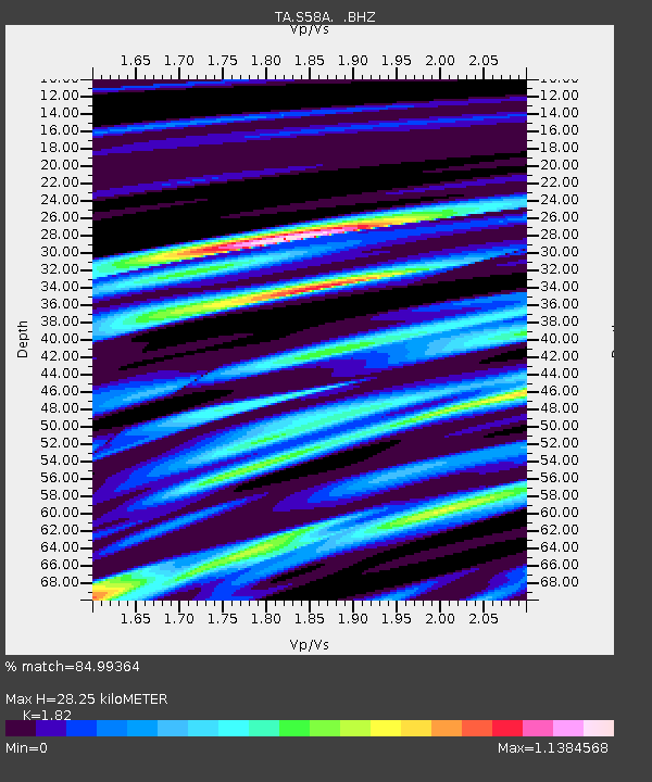
| Estimated Moho Depth: |
28.25 km |
| Estimated Crust Vp/Vs: |
1.82 |
| Assumed Crust Vp: |
6.419 km/s |
| Estimated Crust Vs: |
3.527 km/s |
| Estimated Crust Poisson's Ratio: |
0.28 |
|
| Radial Match: |
84.99364 % |
| Radial Bump: |
400 |
| Transverse Match: |
58.290943 % |
| Transverse Bump: |
400 |
| SOD ConfigId: |
626651 |
| Insert Time: |
2014-05-24 15:11:29.319 +0000 |
| GWidth: |
2.5 |
| Max Bumps: |
400 |
| Tol: |
0.001 |
|

Signal To Noise
| Channel | StoN | STA | LTA |
| TA:S58A: :BHZ:20140510T14:24:26.524994Z | 20.045116 | 1.301722E-6 | 6.4939606E-8 |
| TA:S58A: :BHN:20140510T14:24:26.524994Z | 8.900626 | 5.411E-7 | 6.0793475E-8 |
| TA:S58A: :BHE:20140510T14:24:26.524994Z | 10.16502 | 5.124198E-7 | 5.041011E-8 |
| Arrivals |
| Ps | 3.8 SECOND |
| PpPs | 12 SECOND |
| PsPs/PpSs | 16 SECOND |


