You are here: Home > Network List > TA - USArray Transportable Network (new EarthScope stations) Stations List
> Station T55A Pulaski, VA, USA > Earthquake Result Viewer
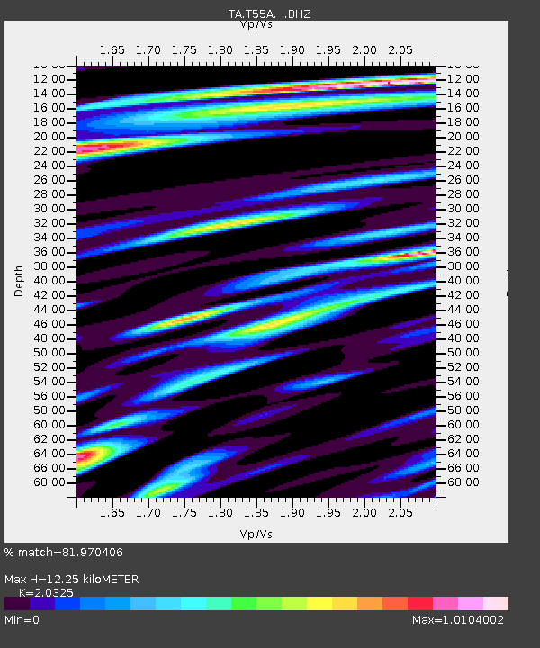
T55A Pulaski, VA, USA - Earthquake Result Viewer
| Earthquake location: |
Southern Alaska |
| Earthquake latitude/longitude: |
60.0/-152.2 |
| Earthquake time(UTC): |
2014/05/10 (130) 14:16:08 GMT |
| Earthquake Depth: |
96 km |
| Earthquake Magnitude: |
5.8 ML, 5.5 MI, 5.7 MWP |
| Earthquake Catalog/Contributor: |
NEIC PDE/NEIC COMCAT |
|
| Network: |
TA USArray Transportable Network (new EarthScope stations) |
| Station: |
T55A Pulaski, VA, USA |
| Lat/Lon: |
37.12 N/80.78 W |
| Elevation: |
644 m |
|
| Distance: |
49.6 deg |
| Az: |
83.882 deg |
| Baz: |
321.322 deg |
| Ray Param: |
0.06827684 |
| Estimated Moho Depth: |
12.25 km |
| Estimated Crust Vp/Vs: |
2.03 |
| Assumed Crust Vp: |
6.159 km/s |
| Estimated Crust Vs: |
3.03 km/s |
| Estimated Crust Poisson's Ratio: |
0.34 |
|
| Radial Match: |
81.970406 % |
| Radial Bump: |
400 |
| Transverse Match: |
64.614044 % |
| Transverse Bump: |
400 |
| SOD ConfigId: |
626651 |
| Insert Time: |
2014-05-24 15:12:10.827 +0000 |
| GWidth: |
2.5 |
| Max Bumps: |
400 |
| Tol: |
0.001 |
|

Signal To Noise
| Channel | StoN | STA | LTA |
| TA:T55A: :BHZ:20140510T14:24:19.149994Z | 18.979908 | 1.2798523E-6 | 6.743196E-8 |
| TA:T55A: :BHN:20140510T14:24:19.149994Z | 10.723771 | 7.0640044E-7 | 6.587239E-8 |
| TA:T55A: :BHE:20140510T14:24:19.149994Z | 5.380719 | 4.5365874E-7 | 8.4311914E-8 |
| Arrivals |
| Ps | 2.2 SECOND |
| PpPs | 5.8 SECOND |
| PsPs/PpSs | 7.9 SECOND |


