You are here: Home > Network List > TA - USArray Transportable Network (new EarthScope stations) Stations List
> Station U40A Yellville, AR, USA > Earthquake Result Viewer
U40A Yellville, AR, USA - Earthquake Result Viewer
| Earthquake location: |
Southern Alaska |
| Earthquake latitude/longitude: |
60.0/-152.2 |
| Earthquake time(UTC): |
2014/05/10 (130) 14:16:08 GMT |
| Earthquake Depth: |
96 km |
| Earthquake Magnitude: |
5.8 ML, 5.5 MI, 5.7 MWP |
| Earthquake Catalog/Contributor: |
NEIC PDE/NEIC COMCAT |
|
| Network: |
TA USArray Transportable Network (new EarthScope stations) |
| Station: |
U40A Yellville, AR, USA |
| Lat/Lon: |
36.36 N/92.85 W |
| Elevation: |
374 m |
|
| Distance: |
44.2 deg |
| Az: |
94.916 deg |
| Baz: |
321.677 deg |
| Ray Param: |
0.07176847 |
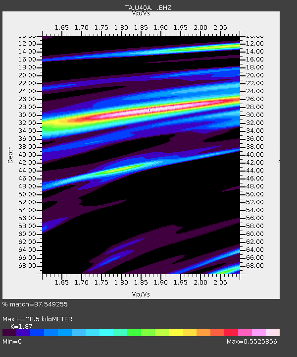
| Estimated Moho Depth: |
28.5 km |
| Estimated Crust Vp/Vs: |
1.87 |
| Assumed Crust Vp: |
6.53 km/s |
| Estimated Crust Vs: |
3.492 km/s |
| Estimated Crust Poisson's Ratio: |
0.30 |
|
| Radial Match: |
87.549255 % |
| Radial Bump: |
400 |
| Transverse Match: |
67.091805 % |
| Transverse Bump: |
400 |
| SOD ConfigId: |
626651 |
| Insert Time: |
2014-05-24 15:12:46.683 +0000 |
| GWidth: |
2.5 |
| Max Bumps: |
400 |
| Tol: |
0.001 |
|

Signal To Noise
| Channel | StoN | STA | LTA |
| TA:U40A: :BHZ:20140510T14:23:36.725006Z | 13.8844185 | 7.987239E-7 | 5.7526634E-8 |
| TA:U40A: :BHN:20140510T14:23:36.725006Z | 11.028577 | 4.4169565E-7 | 4.0050104E-8 |
| TA:U40A: :BHE:20140510T14:23:36.725006Z | 7.6548066 | 2.8316336E-7 | 3.6991576E-8 |
| Arrivals |
| Ps | 4.0 SECOND |
| PpPs | 12 SECOND |
| PsPs/PpSs | 16 SECOND |


