You are here: Home > Network List > TA - USArray Transportable Network (new EarthScope stations) Stations List
> Station U61A Possum Corner Farms, Belvidere, NC, USA > Earthquake Result Viewer
U61A Possum Corner Farms, Belvidere, NC, USA - Earthquake Result Viewer
| Earthquake location: |
Southern Alaska |
| Earthquake latitude/longitude: |
60.0/-152.2 |
| Earthquake time(UTC): |
2014/05/10 (130) 14:16:08 GMT |
| Earthquake Depth: |
96 km |
| Earthquake Magnitude: |
5.8 ML, 5.5 MI, 5.7 MWP |
| Earthquake Catalog/Contributor: |
NEIC PDE/NEIC COMCAT |
|
| Network: |
TA USArray Transportable Network (new EarthScope stations) |
| Station: |
U61A Possum Corner Farms, Belvidere, NC, USA |
| Lat/Lon: |
36.33 N/76.45 W |
| Elevation: |
4.0 m |
|
| Distance: |
52.4 deg |
| Az: |
80.988 deg |
| Baz: |
322.084 deg |
| Ray Param: |
0.06648615 |
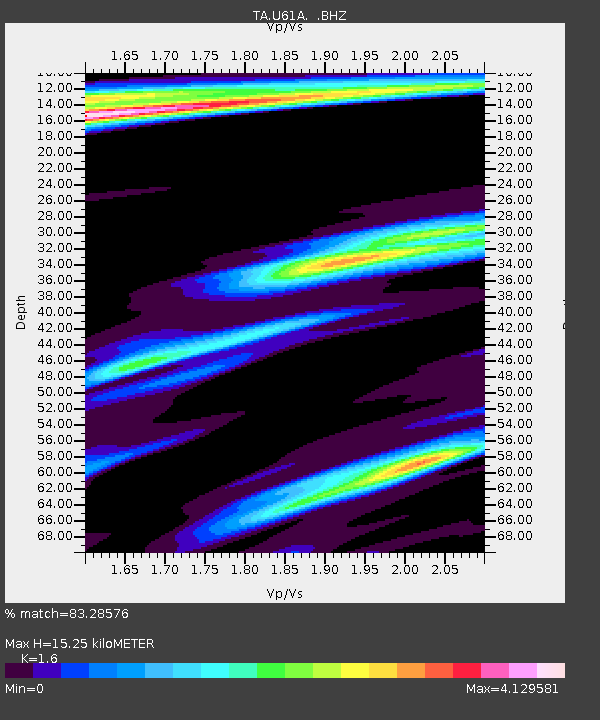
| Estimated Moho Depth: |
15.25 km |
| Estimated Crust Vp/Vs: |
1.60 |
| Assumed Crust Vp: |
6.565 km/s |
| Estimated Crust Vs: |
4.103 km/s |
| Estimated Crust Poisson's Ratio: |
0.18 |
|
| Radial Match: |
83.28576 % |
| Radial Bump: |
356 |
| Transverse Match: |
64.67423 % |
| Transverse Bump: |
400 |
| SOD ConfigId: |
626651 |
| Insert Time: |
2014-05-24 15:13:18.084 +0000 |
| GWidth: |
2.5 |
| Max Bumps: |
400 |
| Tol: |
0.001 |
|

Signal To Noise
| Channel | StoN | STA | LTA |
| TA:U61A: :BHZ:20140510T14:24:39.899994Z | 4.3381987 | 1.6655417E-6 | 3.8392474E-7 |
| TA:U61A: :BHN:20140510T14:24:39.899994Z | 1.0805107 | 8.713125E-7 | 8.0638955E-7 |
| TA:U61A: :BHE:20140510T14:24:39.899994Z | 1.385753 | 7.0884397E-7 | 5.1152256E-7 |
| Arrivals |
| Ps | 1.5 SECOND |
| PpPs | 5.7 SECOND |
| PsPs/PpSs | 7.2 SECOND |


