You are here: Home > Network List > TA - USArray Transportable Network (new EarthScope stations) Stations List
> Station V58A Windy Hill, Pittsboro, NC, USA > Earthquake Result Viewer
V58A Windy Hill, Pittsboro, NC, USA - Earthquake Result Viewer
| Earthquake location: |
Southern Alaska |
| Earthquake latitude/longitude: |
60.0/-152.2 |
| Earthquake time(UTC): |
2014/05/10 (130) 14:16:08 GMT |
| Earthquake Depth: |
96 km |
| Earthquake Magnitude: |
5.8 ML, 5.5 MI, 5.7 MWP |
| Earthquake Catalog/Contributor: |
NEIC PDE/NEIC COMCAT |
|
| Network: |
TA USArray Transportable Network (new EarthScope stations) |
| Station: |
V58A Windy Hill, Pittsboro, NC, USA |
| Lat/Lon: |
35.79 N/79.11 W |
| Elevation: |
127 m |
|
| Distance: |
51.5 deg |
| Az: |
83.573 deg |
| Baz: |
322.113 deg |
| Ray Param: |
0.06706768 |
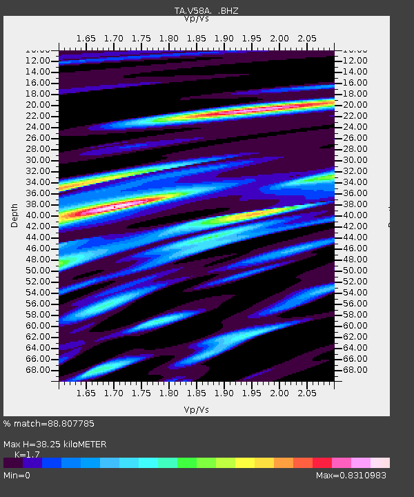
| Estimated Moho Depth: |
38.25 km |
| Estimated Crust Vp/Vs: |
1.70 |
| Assumed Crust Vp: |
6.565 km/s |
| Estimated Crust Vs: |
3.861 km/s |
| Estimated Crust Poisson's Ratio: |
0.24 |
|
| Radial Match: |
88.807785 % |
| Radial Bump: |
400 |
| Transverse Match: |
59.419865 % |
| Transverse Bump: |
400 |
| SOD ConfigId: |
626651 |
| Insert Time: |
2014-05-24 15:13:37.000 +0000 |
| GWidth: |
2.5 |
| Max Bumps: |
400 |
| Tol: |
0.001 |
|

Signal To Noise
| Channel | StoN | STA | LTA |
| TA:V58A: :BHZ:20140510T14:24:33.200012Z | 16.548666 | 1.357941E-6 | 8.205743E-8 |
| TA:V58A: :BHN:20140510T14:24:33.200012Z | 10.203007 | 6.5581895E-7 | 6.427703E-8 |
| TA:V58A: :BHE:20140510T14:24:33.200012Z | 8.085209 | 5.441559E-7 | 6.730264E-8 |
| Arrivals |
| Ps | 4.3 SECOND |
| PpPs | 15 SECOND |
| PsPs/PpSs | 19 SECOND |


